
")
II. Sino-Indian Relationship During the British Rule from 1764-1947
A. The Western Sector
B. The Middle Sector
In the Middle Sector of the Indo-Sino frontier, which stretches from Himachal Pradesh to the Eastern end of the state of Sikkim, there are no major problems, only minor differences occur at few locations, namely Bara Hoti in Uttarakhand (disputed area 80 sq km) and an area adjoining Tibet’s Ngari Province called Ngari Prefecture bordering Himachal Pradesh and Uttarakhand (disputed area 2,000 sq km) which includes Kaurik and Shipki Pass (Himachal Pradesh) and Jadh and Lapthal (Uttarakhand) and ‘The Finger Area’ in the north of Gyangyong in Sikkim (Map 1). Before the British came in contact with the middle sector of India in the early 19th century, parts of Himachal Pradesh, parts of Garhwal and Kumaun (present day Uttarakhand) were under the control of the Shah rulers of Nepal and the Chogyals ruled Sikkim. Here, to provide a perspective to the present issue, we give an account of the historical dealings of the British and, subsequently, of free India with Nepal, Sikkim and Bhutan.
Nepal
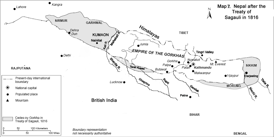
In the middle of the 18th century, a Gorkha king, Prithvi Narayan Shah, set out to conduct a series of military campaigns and put together what came to be called Nepal. The Shah era began in Nepal after Prithvi Narayan Shah invaded the Kathmandu valley which was at that time the capital of the Malla confederacy. The Malla Dynasty was the ruling dynasty of Nepal from the 12th to the 18th century. Until that time, the Kathmandu valley was referred to as Nepal. The Malla confederacy appealed to the British East India Company to help them. The latter was able to send only an ill-equipped and ill-prepared force (numbering 2500) led by Captain Kinloch in 1767. The Gorkha army easily overpowered this force. After many bloody battles and notably after the Battle of Kritipur in 1767, Prithvi Narayan Shah became quite powerful and in 1769 managed to conquer the Kathmandu Valley. Thus he was able to consolidate the smaller kingdoms of Nepal into a united Nepal. At its pinnacle, the Kingdom of Nepal extended from the Tista River in the east, to Kangara in the west, to the Terai areas in the south and across the Himalayas in the north (Map 2). Nepal had managed to defeat Sansar Chand Katoch, the ruler of Kangra, in 1806 with the help of many provincial chiefs. But Kangara was taken back from Nepal by Maharaja Ranjeet Singh in 1809. Also, a dispute with Tibet over the control of the inner Tingri Valley of Tibet (Map 2) and the mountain passes forced the Chinese Qing Emperor to start the Sino-Nepalese War (1788-1792) which culminated in the defeat of the Nepalese army compelling Nepal to retreat and pay heavy reparations to the Chinese.
Rivalry between Nepal and Britain began when Nepal annexed some of the minor states of the British Empire bordering Nepal. This move by Nepal eventually resulted in the Anglo-Nepalese War of 1814-15. In the beginning the British underestimated the Gorkha army and were defeated by them. But eventually, after a prolonged war, the Gorkha army was defeated and the war ended with the Treaty of Sugauli.
The Sugauli Treaty was signed on 2nd December 1815 and after much discussion between the King of Nepal and the British government in India the treaty was finally ratified on 4th March 1816. Before the Treaty of Sugauli, the territory of Nepal included Darjeeling and Tista in the east, parts of Himachal Pradesh, Nainital, Kumaon and Garhwal Kingdom in the west. As per the treaty, Nepal lost parts of Sikkim including Darjeeling (in West Bengal since 1947), the territories of Kuamon and Garhawal, and most of the lands of the Terai areas (Map 2).
The Mechi River became the new eastern border and the Mahakali river (called Kali or Sharda in India) the western boundary of the Nepalese kingdom. The British East India Company agreed to pay 200,000 rupees annually to Nepal to compensate for the loss of income from the Terai region. The treaty stipulated the establishment of a British representative in Kathmandu and allowed them to recruit Gorkhas for military service in their army. The treaty also restricted Nepal form hiring any British, European or American subjects in their service without the express consent of the British Government.
The Terai areas, however, proved difficult for the British to govern and some of them were returned to Nepal later in 1816 and the annual payments were accordingly stopped. Later, the British rewarded Nepal for its help in suppressing the Indian rebellion (war of independence) in 1857 by transferring some more Terai areas to it in 1860.
By the above mentioned treaty of Sugauli, the territorial extent of the Kingdom of Nepal was redefined and to the present day it remains virtually unaltered. The Sugauli Treaty was superseded by a treaty of perpetual peace and friendship signed in 1923. In 1947, when India became free, it took steps to maintain good relations with Nepal. In 1947 Tibet urged the government of India to return to it its territories in Ladakh, Bhutan and Sikkim which, it claimed, were unjustly occupied by the British. Therefore, after the establishment of the Communist regime in 1949 in China, India felt the need of securing the frontiers of Nepal, Bhutan and Sikkim with Tibet. As a result, the Indo-Nepal treaty of Peace and Friendship which provided for the free movement of people and goods between the two countries and a close relationship and collaboration on matters of defence and foreign affairs was signed at Kathmandu on 31st July 1950. At present the border of Nepal with India is practically the same as was defined by the treaty of Sugauli. However, some minor areas namely, Antudanda (Nepal), Nawalparasi (Nepal), Kalapani (India), and Susta (Nepal), continue to be dispupted.
Sikkim
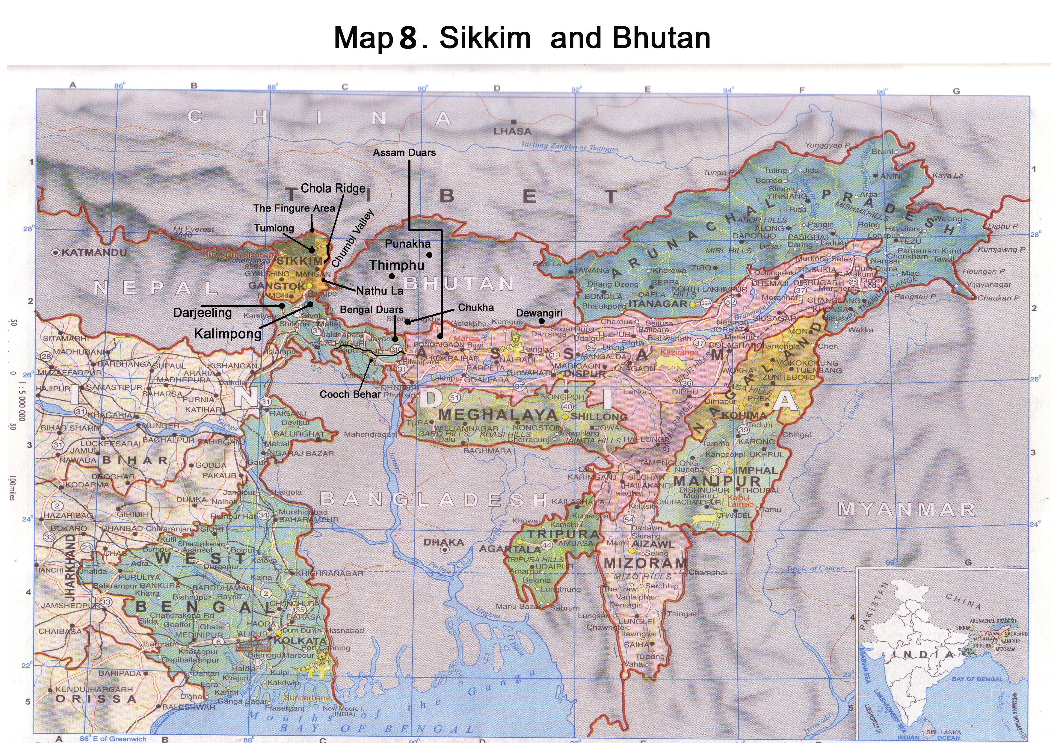
Not much is known about the ancient history of Sikkim. According to the legend, the Buddhist saint Guru Rinpoche passed through the present day Sikkim and introduced Buddhism to Sikkim. In the 13th century, Guru Tashi, a prince from Minyak House in Kham in Eastern Tibet, settled down in the Chumbi Valley. In 1642, a descendant of Guru Tashi, Phuntsog Namgyal, was consecrated as the first Chogyal (king) of Sikkim. The Chogyal then annexed the Chumbi Valley and parts of the present-day Darjeeling district from the Lepcha tribes. From 1700 to 1706, under the third Chogyal ruler, most parts of Sikkim faced invasion from Deb Naku Zidar, the king of Bhutan. Due to this invasion the ruler of Sikkim went into exile in Tibet. The Tibetan army then interfered on behalf of the Sikkimese ruler and expelled the Bhutanese army and established him again in Sikkim. In 1733, under Phuntsog Namgyal II, Sikkim was again under continuous attack from both Bhutan and Nepal.
The rise of the Gorkhas posed a threat to the kingdom of Sikkim. In later years of 1774, Nepal invaded Sikkim and made inroads into the Sikkimese territory. After a peace treaty with Nepal was signed by Sikkim in 1775, the Nepalese army pulled out and promised to abstain from further attacks. But in 1780, Nepal violated the treaty and occupied some of the western territories of Sikkim. The defeat of Nepal by the Chinese in 1792 did little to weaken the expansionist designs of Nepal. They continued to make inroads into Sikkim.
In the early years of the 19th century, to counter the threat of Nepal and Bhutan, the ruler of Sikkim allied with the British. The British were also keen to befriend Sikkim. They felt that by doing so, the expanding power of Nepal would be curtailed and they would be able, via Sikkim, to establish trade links with Tibet. This infuriated Nepal and in vengeance they attacked Sikkim in 1810 overrunning most of the areas including the Terai. In this attack, some parts of the British Empire were also overrun. This and other border incursions by Nepal in later years prompted the British to attack Nepal which resulted in the Anglo-Nepalese war of 1814-15. After the war, the treaty of Sugali was signed between Britain and Nepal in 1815 and the Treaty of Titalia was signed between Sikkim and Britain in 1817. As per the treaties, the territories annexed by Nepal were to be returned to Sikkim. The Treaty of Titalia brought Sikkim under the British influence.
Meanwhile, as pointed out earlier, the British were looking to establish trading links with Tibet. As an offshoot of the ancient Silk Road passed through Sikkim, the British considered the Kingdom of Sikkim as ideal for a transit route to Tibet. In 1835, the British forced Sikkim to cede the town of Darjeeling to them against a onetime payment of Rs 35,000 as compensation. Because of the increased importance of Darjeeling, many citizens of Sikkim, mostly of the labour class, started to settle there as British subjects. The migration disturbed the feudal lords in Sikkim who resorted to forcibly getting the migrants back to Sikkim. This annoyed the British Government which considered these as tantamount to a kidnapping of the British citizens. The relations deteriorated to such an extent that when Dr. Campbell, the Superintendent of Darjeeling and Dr. Hooker visited Sikkim in 1849 in connection with the latter’s botanical research, they were captured and imprisoned. The British issued an ultimatum and the two captives were released after a month of detention. In February 1850, an expedition was sent to Sikkim which resulted in the annexation of a greater portion of Sikkim to British India and the stoppage of the annual grant of Rs. 6000/- which was being paid to the Chogyal of Sikkim by the British.
Sikkim again resorted to making inroads into the British territories. To counter these, in November 1860, the British again sent an expeditionary force to Sikkim. This force was driven back. A stronger force was sent in 1861 which resulted in the capture of the capital Tumlong and the signing of a Treaty between the British and the Sikkimese. The treaty established Sikkim as a princely state under British paramountcy and the British were given the rights of free trade and of building roads in Sikkim. In 1886, the British started building roads into Sikkim. This was viewed by the Tibetans with suspicion and in December 1886 the Tibetan forces attacked Sikkim and in subsequent years occupied several parts of northern Sikkim. In May 1888, the British attacked the Tibetans and by September 1888, the Tibetans were driven out of Sikkim. Following this incident, a British political officer Claude White was appointed to assist the Chogyal in the administration of Sikkim’s domestic and foreign affairs and thus, in effect, the British became the virtual rulers of the state. Later, in 1918, Sikkim was granted complete autonomy in all its domestic affairs.
When India gained independence, a proposal for Sikkim to join the Indian Union failed to secure majority in the popular vote of 1948. Therefore, Prime Minister Nehru agreed for a special protectorate status for Sikkim. By this, Sikkim became a protectorate of India and India controlled its external affairs, defence, diplomacy and communication. Till the death of Nehru in 1964, the status of Sikkim as an independent protectorate was carefully preserved but after Indira Gandhi came to power in 1966, she became increasingly unhappy with Sikkim’s status as a protectorate. The Chogyal, who was a heavy drinker, was viewed by India as politically unstable and dangerous, and the suspicion gained weight, especially after his American wife Hope Cooke published an article demanding the return of certain former Sikkimese properties which she claimed were earlier occupied by the British. In 1967, Indian and Chinese forces clashed at Nathu La and Chola Ridge (Map 3). In September 1967, in Nathu La when the Indian soldiers were protecting an engineering team that was fencing the northern side of Nathu La, the Chinese soldiers opened fire on them. The war escalated over the next five days which saw heavy mortar firing from both sides. Though the Chinese had launched a heavy attack at Nathu La, they were pushed back by the Indian soldiers. Soon after this, the Indian and Chinese forces again clashed at Chola Ridge. On 1st October 1967, some Indian and Chinese soldiers argued over the control of a boulder at Chola outpost in Sikkim. This triggered a fight between the two armies that escalated to a mortar and heavy machine gun duel. On 10th October, both sides again exchanged heavy fire and after heavy fighting the Indian army forced the Chinese to withdraw nearly three kilometres from Chola where they remain deployed till date. Although China withdrew at that time from Sikkim, ‘The Finger Area’ (Map 3) in the north of Gyangyong in Sikkim is still claimed by them.
By the beginning of 1970, there were rumblings in the political rank and file of Sikkim demanding the abolition of monarchy and the establishment of a democratic setup. This finally culminated in a widespread agitation against the Sikkim Durbar in 1973.There was a complete collapse in the administration. The Indian Government tried to bring about a semblance of order in the state by appointing Mr. B. S. Das as the Chief administrator. In early 1975, the Prime Minister of Sikkim appealed to the Indian Parliament for Sikkim’s representation in it by change of its status from a Protectorate to that of a State. On 14th April 1975, a referendum was held in which Sikkim voted to merge with the Union of India. On May 16th, 1975, Sikkim officially became a state of the Indian Union and Lhendup Dorji, the former Prime Minister of Sikkim, became the Chief Minister.
Bhutan
In the early eighteenth century, Bhutan had gained political influence over the principality of Cooch Behar (at present in West Bengal). In 1730, when the Mughals invaded Cooch Behar, the Raja of Cooch Behar sought assistance from Bhutan against them and as a result the Mughals were defeated by the joint forces of Cooch Behar and Bhutan. This enabled the Durk Desi, the ruler of Bhutan, to exercise some political influence over the state of Cooch Behar. By the mid-1760’s Bhutan considered Cooch Behar its dependency and started interfering in its civil administration. In 1772, when a dispute arose over the succession to the throne in Cooch Behar, the Durk Desi of Bhutan attacked and captured Cooch Behar. To expel the Bhutanese, the Raja of Cooch Behar signed a treaty with the British East India Company on 5th April 1773, and the kingdom of Cooch Behar became a dependency of the British. Under this treaty, the British expeditionary forces drove the Bhutanese army out of Cooch Behar and invaded Bhutan. Being under heavy pressure, the Durk Desi petitioned Lhasa for assistance against the British forces but he failed to receive any help from the Tibetans.
Failing to get any assistance from Tibet, Bhutan signed a Treaty of Peace with the British on 25th April 1774, agreeing to return to its pre-1730 boundaries, to pay a tribute of five horses to the British, and to have trade and commerce with them. Subsequently, in 1776, 1777 and 1783, missions were sent by the British to Bhutan. In 1784, the British gave back the control of parts of the Bengal Duars to Bhutan.
Boundary disputes plagued Bhutanese-British relations. To reconcile their differences, Bhutan sent an emissary to Calcutta in 1787 and the British sent missions to Thimphu in 1815 and 1838. The 1815 mission was inconclusive. The 1838 mission offered a treaty providing for extradition of Bhutanese officials responsible for incursions into Assam, free and unrestricted commerce between India and Bhutan, and settlement of Bhutan’s debt to the British. In an attempt to protect its independence, Bhutan rejected the British offer. Despite increasing internal disorder, Bhutan had, more or less, maintained its control over a portion of the Assam Duars since the loss of Cooch Behar as a dependency in the 1760s. After the British gained control of Lower Assam in 1826, tension between the two began to rise as Britain asserted its power. Bhutan’s payments of annual tribute to the British for the Assam Duars gradually fell into arrears. As a result of this the British made incursions into Bhutan in 1834 and 1835 which brought about the defeat of Bhutanese forces and a temporary loss of some territory. In 1841 the British again made inroads into Bhutan and annexed some parts of the Assam Duars against the provision of an annual payment of Rs. 10,000 as compensation to Bhutan. In 1842, Bhutan gave up the control of some of the troublesome Bengal Duars territory it had administered since 1784 into the hands of the British.
Amidst the charges and counter charges of border incursions, Bhutan sent a mission to Calcutta in 1852 which was not successful in settling the differences. Among other demands, the mission had sought increased compensation for its former Duar’s territories, but instead, the British deducted nearly 3,000 rupees from the annual compensation and demanded an apology for the alleged plundering of British-protected lands by the Bhutanese. Following more incidents and the prospect of an anti-British rebellion in the British controlled Bengal Duars, the British troops were deployed to the frontier of Bhutan in the mid-1850s. The Sepoy Rebellion (first war of independence) in India in 1857-58 and the demise of the British East India Company’s rule prevented immediate British action. Bhutanese armed forces raided Sikkim and Cooch Behar in 1862, seizing people, property, and money. The British responded by withholding all compensation payments and demanded release of all captives and return of stolen property. Demands to the Druk Desi went unheeded, as he was alleged to be unaware of his frontier officials’ actions against Sikkim and Cooch Behar.
In the early 1864, after the conclusion of a civil war in Bhutan, the British sent a peace mission to Bhutan. But the new Druk Desi, who had emerged victorious from the civil war, rejected the peace and friendship treaty offered by the British. This infuriated the British and they declared war on Bhutan in November 1864. The war known as the Duar War (1864-65), lasted for five months and resulted in the defeat of Bhutan. On November 11, 1865, the Treaty of Sinchula was signed between the British government in India and Bhutan. According to this treaty, Bhutan ceded all the territories of the Assam Duars and Bengal Duars to the British and the territory of Dewangiri in south-eastern Bhutan, in return for an annual subsidy of 50,000 rupees.
During the 1870s and 1880s, rivalry arose among different regional governors of Bhutan in which Ugyen Wanghuck, the Ponlop (governor) of Tongsa, was victorious and became the national leader of Bhutan. He gradually established a new hereditary monarchy in Bhutan. In early 1910, concerned about the increasing influence of the British over Tibet, the Chinese invaded Tibet and asserted their political authority there. China not only laid claim over Tibet, but also over Bhutan, Nepal and Sikkim. These events brought Bhutan and the British closer to each other. On January 8, 1910, the Treaty of Punakha was signed between Bhutan and the British government. According to the Treaty the British agreed to double their annual stipend to 100,000 rupees and to abstain from interfering in the internal affairs of Bhutan. In return, Bhutan agreed to be guided by the advice of the British Government in regard to its external relations. The Treaty of Punakha guaranteed Bhutan’s defense against China and put an end to the millennium long Tibetan-Chinese influence there. Bhutan also assigned land in Motithang (Thimphu) and a hill station between Chukha and Thimphu to the British and in return the latter assigned a portion of Kalimpong (Bhutan House) to Bhutan.
In 1924, Ugyen Wanghuck sought British assurance that his family would retain its preeminent position in Bhutan. This request led to the question of the legal status of Bhutan. The British, for the time being, did not want to go into the issue and kept things as they were. In 1932, the issue of Bhutan and its relation with British India re-emerged. It was then decided to leave it up to Bhutan whether or not it wished to join the Indian Federation when the time came for such a decision. When India became free in 1947, it succeeded Britain as the de facto protector of Bhutan. On 8th August 1949, the Treaty of Friendship was signed between India and Bhutan. According to this treaty, Bhutan’s external affairs were to be guided by India but India agreed not to interfere in Bhutan’s internal affairs. India also agreed to increase the annual subsidy to 500,000 rupees per year and return Dewangiri, which was taken by the British after the Duar War (1864-65), back to Bhutan. In 2007, India re-negotiated the treaty of 1949 and replaced it by a new treaty of friendship. According to the provisions of the new treaty Bhutan became a sovereign country.

Middle Sector
Nepal After the treaty of Sagauli, 1816
Sikkim And Bhutan