
")
II. Sino-Indian Relationship During the British Rule from 1764-1947
A. The Western Sector
a. Ladakh-Tibet Border
b. Ladakh-Sinkiang (China) Border
In 1960, on the insistence of Premier Chou Enlai, Prime Minister Nehru agreed to convene talks between Indian and Chinese border experts. The officials nominated by the two countries held 47 meetings over a period of six months from 15th June to 12th December 1960 in three different locations namely Delhi, Beijing and Rangoon. During these meetings the Chinese and the Indian officials received clarifications from each other on the border issue. After the conclusion of these meetings, on 14th February 1961 the Government of India’s report on border dispute was published. In this Report, the Indian government produced evidence to prove that the boundary between Ladakh and Sinkiang was well established even before the coming of the British in India. To prove its case this Report produced copies of unofficial maps published in China, India and other countries. The first map produced showed that at the end of the sixth century, the Kuenlun Mountains formed the southern limits of Sinkiang. The second map, which was drawn by Jen Chao, a Buddhist priest, in 1607 showed that the Tsungling (Kuenlun and Pamir, see attached Map 1), lay between India on the one hand and Sinkiang and Tibet on the other. The next map that was presented by the Indian side was from Chin ting which was published by a Commission set up by the scholars and officials in Peking in 1321. This work of Chin ting contained a number of maps of Sinkiang. The maps in this work clearly showed that the Tsungling Mountains (Kuenlun mountain system), formed the southern boundary of Sinkiang. Next, an unofficial Chinese map, published by the Peking University in November 1925, was presented showing the extent of the Chinese Empire under the Ching dynasty, which ruled until 1911. According to this map, the Aksai Chin area was not included in China under the Ching dynasty. Of course, all this did not unequivocally define the Indo-China boundary. Imperial dynasties historically never occupied all that constitutes China or India today.
Along with the above mentioned maps, the Report also cited as proof writings and maps by individual Chinese travellers who travelled in these areas during the nineteenth century. Thus the varied evidence in the Report including contemporary chronicles, reports of individual travellers and unofficial maps showed that the Ladakh-Sinkiang (China) border has been well defined for many centuries. It is, however, important to note that, the British did not take India’s border with Sinkiang as historically settled. They were far from being confident in this matter. And in spite of their determined efforts, they were not able to arrive at any definite understanding with China on the Ladakh-Sinkiang border. As a result, the Ladakh-Sinkiang border was still undefined according to a map showing the political reorganization of India up to March 31, 1948 printed in the publication “Notes, Memorandum and Letters Exchanged between the Government of India and China”, New Delhi, Government of India, July 1948 (Map 4).
During the nineteenth century the British frontier policy in the northwest of India was guided and determined, to a large extent, by the imperialistic Russian threat, as the two European powers were in the process of expanding their territories and protecting their frontiers without confronting each other directly. Due to the advance of the Russians into Tashkent and Samarkand and right up to the borders of Afghanistan, the British government was very keen and eager to define the border with China. By the 1840s the British government in India had acknowledged the paramountcy of China over Tibet and as the British were making serious efforts to determine the northern territorial limits of their empire, they felt it was necessary to involve the Chinese in the process. So within three months of signing the Treaty of Amritsar in 1846, the British Government set up a Boundary Commission in order to demarcate the eastern and northern boundary of the state of Jammu and Kashmir. To secure Chinese cooperation in this matter, the British plenipotentiary at Hong Kong, Sir John Davis, wrote to the Chinese High Commissioner Chiyang at Canton that the British government in India wanted to maintain good relations with China and for this it was necessary to exactly demarcate the boundary between China and the British India.
The letter of Davis makes it clear that the British were trying to get the Chinese cooperation regarding the following two boundaries: (i) the boundary between Tibet and the British Indian territories which were ceded by Nepal at the end of the Anglo-Nepalese war of 1815-16 (Map 3), and (ii) the boundary of the state of Jammu and Kashmir with Tibet in the east and Sinkiang in the north. During the 1840’s the British were not keen to adopt an expansionist policy towards Tibet because of their bad experience in Afghanistan. Therefore, in properly demarcating this border, the British government’s main concern was to maintain peace and security along the areas bordering Tibet and Sinkiang.
To get the Maharaja of Kashmir’s cooperation in this venture, the British government sent a letter to the Maharaja asking him to depute two intelligent men to work with the officers of the Boundary Commission for the demarcation of the boundary. The British appointed Vans Agnew as the head of the first Boundary Commission who established contact with the Chinese Amban in Lhasa and informed him of the changes in the territories resulting from the Treaties of Lahore and Amritsar and about the appointment of the Boundary Commission to settle the boundaries. The British requested the Chinese Amban to depute two confidential agents who would be helpful in pointing out the limits of the Chinese territories. The British also informed the Chinese about the decision of the Governor General to change certain provisions of the 1842 Treaty of Leh signed between the Tibetan Government and the Maharaja of Kashmir. It was pointed out that the reason for the changes in the provisions was to remove the difficulties the British Indian subjects might face while conducting trade with Tibet.
In spite of their earnest efforts, the British Government failed to get Chinese cooperation for the demarcation of the boundary because the Chinese were very distrustful of the British especially after the Treaty of Nanking in 1843 after the First Opium War (1839-42). By this treaty the British got control over Hong Kong and also got 21 million dollars as war indemnity. The Chinese were also obliged to open four ports – Canton, Foochow, Ningpo and Shanghai – for foreign trade. Therefore, when the British asked for Chinese cooperation for discussions on Tibet’s trade and border, the Chinese were very reluctant to further grant any commercial rights to the British regarding Tibet. Their view was that trade was already covered by the recent maritime commerce treaty concluded between the two countries. Moreover, as far as the borders were concerned, the Chinese view was that the borders were well defined and it would be convenient to adhere to the existing arrangements. However, Davis succeeded in convincing Chi Ying, the Chinese High Commissioner at Canton, that the maritime commerce treaty between China and Britain was different from the border trade between British India and Tibet. Finally Chi Ying acquiesced and agreed to transmit the British request to the Chinese Emperor.
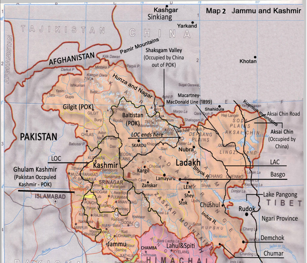
Despite the two boundary commissions which were set up by the British Government in 1846 and 1847 – one headed by Vans Agnew in 1846 and the second headed by Alexander Cunningham in 1847 – they failed to get the Chinese to cooperate. The report submitted by Vans Agnew was the first report which properly tried to define the northern boundary of the state of Jammu and Kashmir. In the eastern side Agnew’s boundary line joined Chushul, Demchok and Lanak-La (Map 2). Running northwards the line ran along the Karakoram Range and included the valleys of Shyok, Galwan and Chip Chap rivers on the Indian side and ended at the Karakoram pass.
In spite of the Chinese non-cooperation, the British’s attempts to define the border were not in vain, there were some positive results obtained by the Boundary Commissions. One of the important achievements of the first Boundary Commission was the determination of the Indo-Kashmir boundary. Due to the exchange of territories Spiti became part of the British domains and the trade route between Rampur Bashahr (Himachal Pradesh) and Gartok (Tibet) came under British control. In his Memorandum of 13th May 1847, Vans Agnew clearly indicated the boundaries of Lahaul and Spiti and also pointed out that the Karakoram Range constituted the limit of the territory of Gulab Singh. During his explorations, as the head of the Boundary Commission, Agnew went up to Gilgit (Map 1) from Ladakh and the information he could get on the traditional boundary was that it went along the Karakoram ranges between Yarkand and Nubra and as far as Hunza and Nagar (Map 1). His description of the Sino-Ladakh border included the Chang Chenmo valley into Ladakh before it joined the Karakoram Range (Map 2). According to him Lanak-La at the eastern extremity was also within the territory of Kashmir.
1. “Johnson Line” of 1865
“Since the two Boundary Commissions failed to secure Chinese cooperation in the determination of Tibet’s borders with Kashmir, the Indian government decided to act unilaterally to ascertain the limits of Britain’s imperial domain, by determining the traditional boundary between Tibet and India, and Tibet and the princely state of Jammu and Kashmir. This could be done through exploration, survey and through mapping of the border areas, with the help of the local officials. Mapping of the Indo-Tibet border started soon after the British had annexed Kumaun and Garhwal. The border in that area was well known since it was essentially the border between Tibet and the kingdom of Nepal, along the Himalayan divide. Strachey started surveying the borders of Kumaun in 1846 where he met the local Bhotias whose services proved to be particularly useful in 1847 in determining the traditional boundary between Tibet and India. It was from the materials that Strachey had collected during his surveys, assisted by the Bhotias, that he had drawn the sketch maps of the border areas. In 1851, the Survey of India had published two maps based on these surveys; and these maps were later incorporated in the Atlas of Northern Frontiers of India, first published by the Government of India in 1959, after the India-China differences on the border issue had come into the open. It is important to realize that Strachey was not a professional surveyor, nor did he have access to the mechanical tools that a modern day surveyor may use at high altitudes. Strachey’s sketches of areas between two established high points, therefore, were likely to be approximate. This, however, in no way minimizes the importance of his work in determining the traditional boundary between Tibet and India. As one looks back on the work of the two Boundary Commissions, it becomes clear that there was no chance of the Chinese imperial authorities agreeing to the determination of the India-China/Tibet border through negotiations between wandering British and Chinese Boundary Commissioners. If any success was to be achieved in this matter, it would require negotiations between the British and Chinese Governments, on the basis of specific proposals. However, no serious effort was made by the British Foreign Office in London to start such negotiations with the Chinese, on the basis of specific proposals, till the 1890s; and when the British Government eventually presented definite proposals for determination of the Kashmir-Tibet boundary, the Chinese were elusive in their response.
Survey operations began in Kashmir in 1855. The purpose of these surveys was to determine the extent of India’s boundary so that the matter could be taken up later for negotiations with the Chinese. However, the maps prepared by the Survey of India on the basis of these surveys, depicting India’s boundaries with China which were, in effect, no more than claim lines, became mired in controversies. A key figure in the controversy over Kashmir’s boundary in the north and the east, was W. H. Johnson, a civil sub-assistant to Major Montgomery who was in charge of survey operations in Kashmir. Johnson was assigned the responsibility for surveying north eastern Ladakh and he was in Ladakh in 1865 at a time when Chinese rule had virtually collapsed in the westernmost territories of China; and by 1860 a new state, Kashgaria (Kashgar), had come into existence under Yakub Beg. Taking advantage of this, the Maharaja of Kashmir sought to extend his kingdom beyond the Karakoram Pass and succeeded in establishing a Chauki in Shahidula in 1854, although by 1857, the Maharaja’s men had been driven out from the post. By 1877, the Chinese had re-established their control over Kashgaria and made it into a province of China—Sinkiang. But the boundary of Ladakh shown in Johnson’s map, after his visit to the Karakoram Pass, Suget and Shahidula, showed the entire territory between the Karakoram Pass and the Kuenlun range as falling within the province of Ladakh. Johnson’s motives are not above suspicion. For his survey operations in Ladakh, Johnson depended on Mangal Mehta’s assistance for logistical support and safe conduct, and it is not inconceivable that his views were influenced by Mehta, the Wazir of Ladakh.
Moreover, Johnson himself was eyeing a job under the Maharaja’s dispensation and, in fact, was later appointed the Wazir of Ladakh. It is quite possible, therefore, that in depicting Ladakh’s boundary with Tibet, he took a position favouring the Maharaja’s claims to territories that did not belong to him. Doubts about the correctness of Johnson’s boundary are also justified because at least three other British travellers — Forsyth, a senior government official, Robert Shaw, an English writer and Hayward, who were in Ladakh closely on the heels of Johnson — had all rejected his boundary claims, and reverted to the watershed boundary of the Karakoram-Changlang range.”1
In the later years, the Johnson boundary assumed a very important place in context of the discussion on the Sino-Indian border. The then British Forward School strategists (who were of the view that Britain should advance forward and meet the Russian threat directly) had advocated that India’s borders with China should be along the Kuenlun range. The maps issued by Survey of India had originally shown the Karakoram Chang Chenmo watershed as British India’s boundary with Tibet, but later the maps were changed and the boundary was extended to the Kuenlun range. However, a controversy developed after the first edition of the Turkestan map was prepared by the Survey of India. This map showed the boundaries of the British Empire and the Russian Empire. In this the boundary of Ladakh was shown along the Kuenlun range. On 28th July 1873, in his letter to the Surveyor General, the Superintendent of Survey, Walker, gave some reasons for expanding the boundary up to the Kuenlun range as shown in the Turkestan map. He wrote that the change was brought about because Johnson had visited Khotan (Map 2), and on his way he found a Chauki established at Shahidula by the Maharaja of Kashmir and also because the Maharaja was claiming that Ladakh’s boundary extended up to the Kuenlun range.
“Why was this extended boundary of Ladakh as shown in the new Turkestan map, based on the exaggerated claims of the Maharaja, not corrected? … Walker’s explanation was ingenious. He explained to the Surveyor General that any correction would be inappropriate since several copies of the map had already been circulated, including the copies sent to England, and, the two copies sent to Russia. It became known in 1873 that Walker had been regularly exchanging maps with his Russian counterpart. The Russians, obviously, took interest in British maps to ascertain the extent of India’s boundary claims, just as the Indian government was interested in Russian maps. Walker, however, added two comments in his report to the Surveyor General which are significant. First, he pointed out that the maps published by the Survey of India were not necessarily issued with the authority of the Government of India, thereby leaving room for later manoeuvres. What is more, Walker categorically stated that with certain exceptions, ‘no boundaries… have as yet been defined, and therefore everyone should understand that the map cannot be considered conclusive regarding hitherto undefined boundaries. Nevertheless, the advanced boundary of Ladakh, as shown in the first edition of the Turkestan map, was incorporated in the maps of some cartographers such as Keith Johnston, adding a new dimension to the subsequent controversy over the Sino Indian boundary during the middle of the twentieth century, since the Johnson boundary included within Kashmir’s territory the whole of Aksai chin — a ‘desert of white stones’.’”2
2. The “Foreign Office Line” of 1873
After the rejection of the Johnson Line by the British Foreign Office, the responsibility of properly demarcating the northern border with China was given to Frederic Drew, Governor of Leh in 1870-71. Drew was the first person who prepared a detailed map of Aksai Chin and highlighted its geographic aspects. His map was based on his own explorations as well as the explorations of Hayward, Shaw and Forsyth mentioned above. According to Drew, the high-altitude east of the Karakoram was divided into three distinct parts by the Lakstang Range (Map 2). North-eastwards flow the streams which form the Karakash river and in the west and north-west flow the Chang Chenmo, the Galwan and the Chip Chap rivers, all of which join the Shyok-Indus system. In the South-western section of the Aksai Chin lies the Depsang Plains and through it passes the route to Shahidula (Qizil Jilga to Haji Langar to Shahidula). In the south-central part of the Aksai Chin lies the Lingzhi Thang Plain. North-east of the Lakstang Range, lies the Aksai Chin proper, known variously as the Kuenlun plains or the Soda plains (Map 2). It was on the description given by Frederic Drew, that the British government drew a line delineating the northern boundary of the state of Jammu and Kashmir. This line is known as the Foreign Office Line of 1873 (Map 2). This line started from Lanak-La, and then moving north-west side it finally joined the Karakoram Range. This line which started from Lanak-La was a little south of the Lakstang Range, which later in 1899 was used to define the Macartney-Macdonald Line.
3. The “Macartney-Macdonald Line” of 1899
Towards the last decade of the nineteenth century British policy towards China was determined mainly by the Russian moves in Central Asia. At this juncture the British were more concerned and worried about the expansionist Russians than the Chinese, since China was internally weak at that time. The British during the 1890s tried to consolidate China as they thought that this will be helpful to them in countering Russia. “In 1889 the then Viceroy Lord Hardinge wrote, for example, that the territory between the Karakoram and Kuenlun ranges being inaccessible, and of relatively little value, the Chinese could be encouraged to take it, since that would be better than having a no man’s land between the frontiers of India and China. ‘Moreover’, he wrote, ‘the stronger we can make China at this point, and the more we can induce her to hold her own over the whole of Kashgar Yarkand region, the more useful will she be to us as an obstacle to Russian advance along this line.’
After the reconquest of Kashgar, first the Chinese tried to consolidate their position, and continued to treat the Kuenlun mountains as constituting the southern limits of their territory, as was done by the rebellious Yakub Beg. But by the 1880s, the Chinese were looking further south in a bid to re-establish their authority in areas they considered as belonging to China. In 1890, when Captain Younghusband went to the Pamirs to ascertain the limits of China’s territory, he was told that the Karakoram mountains constituted the southern limits of China and, as if to assert this claim, they had put up a boundary marker in the Karakoram Pass in 1892, declaring that Chinese territory began from there. This was a unilateral move, but the British did not contest it then, as it seemed to be quite consistent with the ideas held by the British rulers in India, although the alignment of the Sino Indian border on both sides of the Pass as yet remained undefined. Differences emerged between Britain and China over the Aksai chin issue. The issue came up for direct talks between British and Chinese officials in 1896, following Chinese protests over the depiction of Aksai chin as a part of Kashmir in Keith Johnston’s Atlas of 1894, that was presented to the Chinese Taotai of Kashgar. … As noted earlier, the advanced boundary of Ladakh, as shown in the first edition of the Turkestan map, had influenced the work of some cartographers, including Keith Johnston. The boundary alignment of Kashmir, shown in Johnston’s map, as running along the Kuenlun range to a point east of 80°E longitude, placed Aksai chin within Kashmir. This was, in fact, similar to the boundary suggested by Johnson. When Russian officials drew the attention of the Taotai to this map pointing to its adverse consequences for the Chinese, he made a verbal protest to McCartney, the British official at Kashgar, claiming that Aksai chin belonged to China. McCartney sought to explain it by arguing that Aksai chin was “a general name for an ill defined and very elevated table land at the North East of Ladakh” and that “it was probably the case that part [of it]was in Chinese and part in British territory.’ Perhaps McCartney would have liked to have some specific agreement with China concerning the boundary of Aksai chin, but the British Government was not too enthusiastic about the idea, apprehending that it might precipitate Russian interference in Kashgaria. McCartney’s description of the Aksai chin was corroborated by a British intelligence report in the same year.”3
The Russian consolidation of their position in Central Asia was becoming a headache for the British government and by the later years of 1890s the British became determined to define a proper border with China, as this would be helpful to them in determining the future course with Russia. Keeping this in view, in 1897 the British government made a determined effort to come to an agreement with China regarding Kashmir’s border. At this time Viceroy Elgin dispatched India’s first comprehensive boundary proposal for the north-western border to Whitehall. He suggested that a line should be drawn on the watershed principle, including Lingzhi Thang plain as part of Ladakh, thereafter moving west of the Depsang plain upto the Karakoram pass (Map 2). Thus Elgin’s proposal abandoned the Johnson line and made no attempt to include the empty quarters of the Aksai Chin in Ladakh’s territory.
If Lord Hardinge was in favour of strengthening China so that it could be an obstacle for the Russian advance towards India’s north-west frontier, the Forward school strategists did not share his view. Hence, while Elgin’s proposal was still under consideration, the Forward school advocates in the War Office in London took the matter into their own hands. To their advantage they found an important ally in Sir John Ardagh, the Director of Military Intelligence. In 1897 Ardagh completely refuted the watershed principle. “Ardagh recommended that Britain’s border in north India be pushed beyond the watershed to include the Yarkand and Karakash valleys, in order to ‘retain within our territory the approaches to them on the northern side and the lateral communications between these approaches’. He suggested that this would best be achieved by establishing ‘our supremacy and protection [over]the chief of the local tribes, and to assert it by acts of sovereignty . . . and in this manner acquire a title by prescription’. …he even suggested that this principle ‘be applied at a future period to the upper basins of the Indus, the Sutlej and even the Brahmaputra, in the event of a prospective absorption of Tibet by Russia’, implying that to forestall a Russian advance into Tibet, Britain should move across the Himalayan range and occupy Gartok, Shigatse and, inevitably, Lhasa!”4 Ardagh’s proposal was not accepted by the Foreign Department of the Indian Government. The Viceroy, Lord Elgin, wrote to the Secretary of State for India that he and his advisors were not in favour of the Ardagh’s line since it was of no strategic importance to British Government in India. He also added that this line proposed by Ardagh would strain the relations with China and might precipitate Russian interference. Although Ardagh’s views were rejected by the Foreign Department, they continued to influence India’s frontier policy for the next two decades.
The Government of India was well aware of the Russian advance into Central Asia. Indeed, Viceroy Elgin, two years before Ardagh’s proposal was presented, advocated a direct approach to the Chinese to settle the boundary of Kashmir with China. But the Foreign Office was not too keen because the Chinese were embroiled in the Sino- Japanese war. But in 1898, there was a change in the British policy regarding the border issue because the British government learnt that the Chinese and the Russians were settling their frontier of East Turkestan (present day Sinkiang). Consequently, the Government of India informed Whitehall that they should settle boundaries of Kashmir, Hunza and Afghanistan with China. Till 1898, the Government of India had not made any specific proposal to China for defining its borders with Kashmir. The Foreign Department in a despatch to Whitehall (23rd December 1897) had rejected the Ardagh line on the ground that this will be of no strategic importance to India but did not give an alternative proposal which could be presented to the Chinese for negotiations. On 27th October 1898, prompted by the Foreign Office in London, the British government in India came up with its own proposal and sent it to the Secretary of State. The Boundary proposed by the Government of India depicted a line on the crest of the Karakoram Range, moving in the south-east direction following Laktsang Range until it reached the eastern boundary of Ladakh little east of 80 longitude. This line was a modification of the line that was presented by Vans Agnew on 13th May 1847. It was this proposal of the Foreign Department of the Government of India which, on 14th March 1899, was presented to the Chinese authorities, by Sir Claude MacDonald, the British envoy in Peking. This proposal also incorporated the suggestion by Macartney who had proposed that Aksai Chin should be divided between China and Kashmir along the boundary following the Laktsang Range, a line of hills running East West and thus dividing the Aksai Chin proper.
The 1899 boundary line, known as the Macartney-MacDonald line, was the only official boundary line that was ever presented to the Chinese government by the British to define Ladakh’s boundary with China. This line was a compromise between moderate view of Viceroy Elgin and the maximalist’s view of the Forward School strategists like John Ardagh. In the eastern boundary of Ladakh, the MacDonald line left the whole of Karakash Valley, the trade route and almost the whole of Aksai Chin to China, while the Lingzhi Thang salt plains, the whole of the Chang Chenmo valley and the Chip Chap river were left with India (Map 2). “The Chinese Government never sent a formal reply to the British proposal, possibly because they were irked by the suggestion for relinquishing China’s ‘shadowy claims’ to suzerainty over Hunza. Another factor influencing China’s decision might have been her anxieties over Russia’s reactions, had such a proposal been accepted. However, the Chinese Government did not reject the proposal either. Under the circumstances, the British Government could have taken the position, as indeed was suggested by Lord Curzon in 1904, that since the Chinese had not rejected the MacDonald proposal, London would be justified in regarding China’s reticence as a sign of her tacit acceptance of the same, and declaring the MacDonald line as Kashmir’s boundary with China.”5
Even though the Macartney-MacDonald line was accepted by the British in 1904, the British Government vacillated between the Johnson line and the MacDonald line clearly violating international rules and norms. In 1912, following the collapse of the Manchu Dynasty, the British apprehended that the Russians may make a move to occupy Sinkiang. Accordingly, Viceroy Lord Hardinge urged the British government in London that the Johnson Line should form the Ladakh-Sinkiang border but his suggestion was shot down. However, the Bolshevik Revolution of 1917 brought a shift in the British policy and the British shifted the Ladakh-Sinkiang border line from the Macartney-MacDonald line to the Johnson line (Map 2). However, in 1927 as the Russian leaders, mainly Leon Trotsky and Stalin, were embroiled in a mutual conflict regarding the new economic policies and social reforms brought up by Stalin, the British moved backwards, abandoning the Johnson Line in favour of the Macartney-MacDonald Line. It is interesting to note that from 1917 to 1933 the editions of the Postal Atlas of China showed the Kuenlun Range (or the Johnson line) as the boundary between India and China. In 1941, when the British came to know that the Russians were surveying the Aksai Chin area for Sheng Shicai, the warlord of Sinkiang, they again moved to the Johnson line. Until the time the British left India in 1947, they still had not decided which line – the Johnson Line or The Macartney-MacDonald Line – defined the northern border of India with China. The map published by the Government of India in July 1948 showed the northern boundary of India with China as “Boundary Undefined” (map 4). The continuous shift of British policy regarding the Ladakh-Sinkiang border was the reason for the claims and counter-claims regarding the boundary of Aksai Chin. This has been the seed of contention between India and China in the western sector.
(To be continued…)
Jammu and Kashmir map

Aksai chin map

Nepal after 1816

Undifined Boundary newa
References:
1. History of Science, Philosophy and Culture in Indian Civilisation, Volume X, Part 6: Aspects of India’s International Relations 1700 to 2000: South Asia and the World: Edited by: Jayanta Kumar Ray, pp. 189-90
2. Ibid, p. 191
3. Ibid, p. 192
4. War in the Himalayas: The Indian Army in Crisis 1962: D.K. Patil, p. 44
5. History of Science, Philosophy and Culture in Indian Civilisation, Volume X, Part 6: Aspects of India’s International Relations 1700 to 2000: South Asia and the World: Edited by: Jayanta Kumar Ray, pp. 194-95