

An Overview of the Condition of Ground Water in India
Groundwater is the water found underground in the cracks and spaces in soil, sand and rock. It is stored in and moves slowly through geologic formations of soil, sand and rocks called aquifers. The various rock formations with distinctive hydrogeological characteristics act as different aquifer systems of various dimensions. The major rock formations of India can be broadly categorized into 14 Principal aquifer systems based on their broad hydrogeological properties. See figure 1 in the Appendix (p.29) for the map of various aquifers in India.
India is the largest user of groundwater in the world. It uses an estimated 250 cubic kilometers (250 BCM, Billion Cubic Meter) of groundwater per year – over a quarter of the global total. (Table 1)
Table 1: Top 10 groundwater-abstracting countries as of 2010
| Table 1: Top 10 groundwater-abstracting countries as of 2010 |
|
| Country | Abstraction (km3/year) |
| India | 251 |
| China | 112 |
| USA | 112 |
| Pakistan | 64 |
| Iran | 60 |
| Bangladesh | 35 |
| Mexico | 29 |
| Saudi Arabia | 23 |
| Indonesia | 14 |
| Italy | 14 |
| Source: Data from IGRAC (2010) AQUASTAT (2011) and EUROSTAT (2011) | |
a. Ground Water Availability
“As of April 2015, the water resource potential or annual water availability of the country in terms of natural runoff (flow) in rivers is about 1,869 Billion Cubic Meter (BCM)/year. However, the usable water resources of the country have been estimated as 1,123 BCM/year. This is due to constraints of topography and uneven distribution of the resource in various river basins, which makes it difficult to extract the entire available 1,869 BCM/year. Out of the 1,123 BCM/year, the share of surface water and ground water is 690 BCM/year and 433 BCM/year respectively. Setting aside 35 BCM for natural discharge*, the net annual ground water availability for the entire country is 398 BCM. The overall contribution of rainfall to the country’s annual ground water resource is 68% and the share of other resources, such as canal seepage, return flow from irrigation, recharge from tanks, ponds and water conservation structures taken together is 32%. Due to the increasing population in the country, the national per capita annual availability of water has reduced from 1,816 cubic metre in 2001 to 1,544 cubic metre in 2011-12 This is a reduction of 15%.”1
“The ground water level data for November 2016 indicates that out of the total 15566 wells analysed, 2622(17%) wells are showing water level less than 2 m bgl (metres below ground level), 5933(38%) wells are showing water level in the depth range of 2-5 m bgl, 4175 (27 %) wells are showing water level in the depth range of 5-10 m bgl, 1898 (12%) wells are showing water level in the depth range of 10-20 m bgl, 718(5%) wells are showing water level in the depth range of 20-40 m bgl and the remaining 220 (1 %) wells are showing water level more than 40 m bgl. The maximum depth to water level of 122.00 m bgl is observed in Bikaner district of Rajasthan whereas the minimum is less than 1 m bgl.”2
“The distribution of number of wells under different depth ranges is presented in the histogram here. (Note: Data is for Nov 2016)
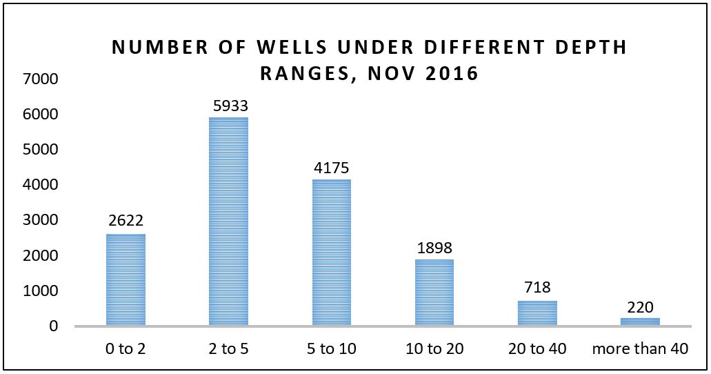
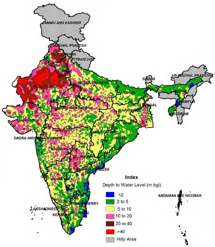
Figure 2
The depth to water level map of January 2016 (figure 2 below) for the country indicates that in general, depth to water level ranges from 2 to 10 m bgl as observed at about more than 65% of the monitoring stations. In sub-Himalayan area, north of river Ganges, northern parts of Uttar Pradesh, northern parts of Bihar, Odisha, Assam, Andhra Pradesh, coastal parts of Maharashtra, and Tripura generally the depth to water level varies from 2-5 meter below ground level. Shallow water level of less than 2 m bgl is observed in the states of Assam and isolated pockets in Andhra Pradesh, Maharashtra, Odisha and Tamil Nadu. In West Bengal the water level generally varies from 2 to 10 m bgl – the central parts of the state show a water level of 10 m and above and deeper water level of more than 20 m bgl in small pockets. In major parts of the north-western states depth to water level generally ranges from 10-40 m bgl. A water level of more than 40 m bgl is also prevalent in the north western part of the country. In the western parts of the country deeper water level is recorded in the depth range of 20-40 m bgl and more than 40 m bgl. In some parts of Haryana, and Delhi and most major parts of Rajasthan, water level of more than 40 m bgl is recorded. Along the eastern coast the water level is generally up to 5 m bgl whereas in the western coast a water level of 10 m bgl is prevalent. In Central India the water level generally varies between 5 m bgl to 20 m bgl, except in isolated pockets where the water level of less than 5 m bgl has been observed. The peninsular part of country generally recorded a water level in the range of 2 to 20 m bgl depth range.
b. Ground Water Extraction and Use
Experts believe that India is fast moving towards a crisis of ground water because of overuse and contamination. Ground water overuse or overexploitation is defined as a situation in which, over a period of time, average extraction rate from aquifers is greater than the average recharge rate.
In India, the availability of surface water is greater than ground water. However, owing to the decentralised* availability of groundwater, it is easily accessible and forms the largest share of India’s agriculture and drinking water supply. 89% of ground water extracted is used in the irrigation sector, making it the highest category user in the country. This is followed by ground water for domestic use which is 9% of the extracted groundwater. Industrial use of ground water is 2%. 50% of urban water requirements and 85% of rural domestic water requirements are also fulfilled by ground water.
- Irrigation through Ground Water
The largest component of ground water use is the water extracted for irrigation. The main means of irrigation in the country are canals, tanks and wells, including tube-wells. Of all these sources, ground water constitutes the largest share. Wells, including dug wells, shallow tube-wells and deep tube wells provide about 61.6% of water for irrigation, followed by canals with 24.5%. (Data: 2011)
Figure 3: Increase in ground water utilization for irrigation
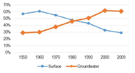
Figure 3
Source: Agricultural Statistics at Glance 2014, Ministry of Agriculture; PRS.
Over the years, there has been a decrease in surface water use and a continuous increase in ground water utilisation for irrigation. Figure 4 illustrates the pattern of use of the main sources of irrigation. As can be seen, the share of tubewells has increased exponentially, indicating the increased usage of ground water for irrigation by farmers. The dependence of irrigation on ground water increased with the onset of the Green Revolution, which was based on intensive use of inputs such as water and fertilizers to boost farm production. Incentives such as credit for irrigation equipment and subsidies for electricity supply have further worsened the situation. Low power tariffs have led to excessive water usage, leading to a sharp fall in water tables.
Figure 4: Tubewells increasingly being the main source of irrigation
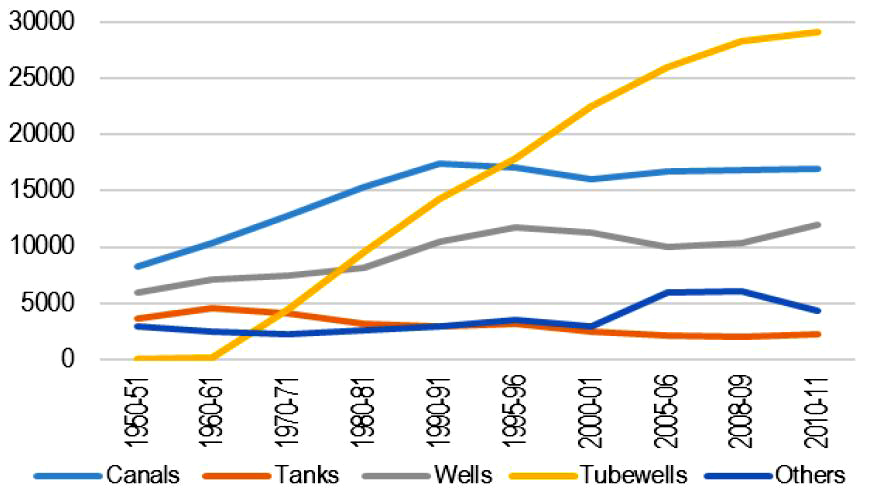
Figure 4
Note: Irrigated area is in ‘000 hectares.
Source: Agricultural Statistics at Glance 2014, Ministry of Agriculture; PRS.
- Agricultural Crop Pricing and Water Intensive Crops
In the last four decades, roughly 84% (54.85 million hectares) of the total addition to the net irrigated area (65.3 million hectares) has come through ground water. The primary cause of over-exploitation has been the rising agricultural demand for ground water. Further, decisions such as cropping pattern and cropping intensity are taken independent of the ground water availability in most areas.
The High-Level Committee on restructuring of the Food Corporation of India in 2014, observed that even though Minimum Support Prices (MSPs) are currently announced for 23 crops, the effective price support is for wheat and rice only. This creates highly skewed incentive structures in favour of wheat and paddy, which are water intensive crops and depend heavily on ground water for their growth. Table 2 below shows the average amount of water (in cubic meters/tonne) needed to grow different crops. It indicates India’s efficiency in the usage of water for agriculture as compared to other countries. As can be seen, India uses almost twice the amount of water to grow crops as compared to China and the United States.
Table 2: Water use for crop production in different countries (in cubic metres/tonne)
| Table 2: Water use for crop production in different countries (in cubic metres/tonne) | ||||
| Crops and Crop Products | Average amount of water needed to grow crops in | |||
| Brazil | India | China | United States | |
| Rice | 3082 | 2800 | 1321 | 1275 |
| Sugarcane | 155 | 159 | 117 | 103 |
| Wheat | 1616 | 1654 | 690 | 849 |
| Cotton | 2,777 | 8,264 | 1,419 | 2,535 |
| Sources: National Water Footprint Account, UNESCO-Institute for Water Education, May 2011; | ||||
- Energy Subsidies and Ground Water Extraction
The practice of providing power subsidies for agriculture has played a major role in the decline of water levels in India. In 2009, of the total amount of ground water extracted, 89% was for irrigation, and 11% was for domestic and industrial uses. Since power is a main component of the cost of ground water extraction, the availability of cheap/subsidised power in many states adds to the greater extraction of this resource. Moreover, electricity supply is not metered and a flat tariff is charged depending on the horsepower of the pump. The Draft National Water Framework Bill, 2013 also suggested that over extraction of ground water should be curtailed by regulating the use of electricity needed for its extraction.”3
- The Looming Crisis
“Groundwater in India is a critical resource. However, an increasing number of aquifers are reaching unsustainable levels of exploitation. If current trends continue, in 20 years about 60% of all India’s aquifers will be in a critical condition says a World Bank report. This will have serious implications for the sustainability of agriculture, long-term food security, livelihoods, and economic growth. It is estimated that over a quarter of the country’s harvest will be at risk. There is an urgent need to change the status quo.”4
“Ground water resources in the country are assessed at different scales within districts, such as blocks/mandals/talukas/watersheds. Ground water development is a ratio of the annual ground water extraction to the net annual ground water availability. It indicates the quantity of ground water available for use. Table 3 on next page compares the level of ground water development in the country over the past two decades. See table 4 in appendix which provides data on ground water development as a percent of water recharge for individual states.
| Level of ground water development |
Explanation | % of districts in 1995 |
% of districts in 2004 |
% of districts in 2009 |
% of districts in 2011 |
| 0-70% (Safe) | Areas which have ground water potential for development | 92 | 73 | 72 | 71 |
| 70-90% (Semicritical) | Areas where cautious ground water development is recommended |
4 | 9 | 10 | 10 |
| 90-100% (Critical) | Areas which need intensive monitoring and evaluation for ground water development |
1 | 4 | 4 | 4 |
| >100% (Overexploited) | Areas where future ground water development is linked with water conservation measures | 3 | 14 | 14 | 15 |
The level of ground water development is very high in the states of Delhi, Haryana, Punjab and Rajasthan, where ground water development is more than 100%. This implies that in these states, the annual ground water consumption is more than annual ground water recharge. In the states of Himachal Pradesh, Tamil Nadu and Uttar Pradesh and the Union Territory of Puducherry, the level of ground water development is 70% and above. In rest of the states, the level of ground water development is below 70%. Over the years, usage of ground water has increased in areas where the resource was readily available. This has resulted in an increase in overall ground water development from 58% in 2004 to 62% in 2011. See Figure 5 in appendix. It shows the categorization of ground water assessment units. (Note: Data as of 2011. Sources: Ground water scenario in India, November 2014, Central Ground Water Board; PRS.)”5
Ground Water Contamination
Along with the problem of depleting water levels, ground water contamination is also on the rise. “Ground water contamination is the presence of certain pollutants in ground water that are in excess of the limits prescribed for drinking water. The commonly observed contaminants include arsenic, fluoride, nitrate and iron, which are geogenic* in nature. Other contaminants include bacteria, phosphates and heavy metals which are the result of human activities including domestic sewage, agricultural practices and industrial effluents. The sources of contamination include pollution by landfills, septic tanks, leaky underground gas tanks, and from overuse of fertilizers and pesticides. It has been pointed out that nearly 60% of all districts in the country have issues related to either the availability of ground water, or the quality of ground water, or both. Table 5 below shows the number of states and districts affected by geogenic contaminants as on July 2014.
Table 5: States and districts affected by geogenic contamination in groundwater
| Table 5: States and districts affected by geogenic contamination in groundwater | ||
| Geogenic contaminants |
Number of affected states |
Number of affected districts* |
| Arsenic | 10 | 68 |
| Fluoride | 20 | 276 |
| Nitrate | 21 | 387 |
| Iron | 24 | 297 |
*Total districts in 2014: 676;
Source: Central Ground Water Board
It was observed that 68 districts in 10 states are affected by high arsenic contamination in groundwater. These states are Haryana, Punjab, Uttar Pradesh, Bihar, Jharkhand, Chhattisgarh, West Bengal, Assam, Manipur and Karnataka.”6
Conclusion
By looking at the figures mentioned above one cannot but arrive at the conclusion that we are heading towards a dangerous water crisis in the country. This will not only affect water availability for drinking but also affect very adversely the agriculture and food security of the country. “The analyses (published in Environmental Research Letters) reveal that even in some areas that experience projected increases in monsoon rainfall, the expansion of irrigated agriculture will lead to more non-renewable groundwater extractions. This means groundwater levels will continue to drop over the next 30 years in these areas. In extreme cases, a complete loss of non-renewable groundwater irrigation can reduce national annual crop production by as much as 25 per cent. Results also point to the large variation in future groundwater levels across India. Under future climate change, notably, some districts will do better and may even be able to rely solely on sustainable water supplies allowing groundwater levels to recover. Others will see slower rates of groundwater decline and yet others will experience declines for the first time. But most of Punjab and Haryana, northern areas of Rajasthan and Gujarat, and parts of Uttar Pradesh and Tamil Nadu will face continued groundwater level declines.”7
With the growing population the demand is ever increasing for water while the level of ground water along with the flow of water in the rivers is depleting at alarming rates. This has created problem of scarcity in many parts of India. “The demand supply mismatch is more severe in certain areas. In urban areas, where the demand of 135 litres per capita daily (lpcd) is more than three times the rural demand of 40 lpcd, the scarcity assumes menacing proportions. Already, Delhi and Chennai are fed with supply lines stretching hundreds of kilometres. According to projections by the UN, India’s urban population is expected to rise to 50% of the total population by 2050. This would mean 840 million people in the most water-starved parts of the country compared with 320 million today. The issue of inequity in water availability has already proved to be fertile ground for several inter-state and intra-state disputes, and unless mitigating steps are taken now, these conflicts would only escalate.”8
Below is the table for the projected water demand in India.
Table 6: Projected Water Demand in India, BCM(Billion Cubic Meter)
| Table 6: Projected Water Demand in India, BCM(Billion Cubic Meter) | |||
| Sector | 2010 | 2025 | 2050 |
| Irrigation | 688 | 910 | 1072 |
| Drinking Water | 56 | 73 | 102 |
| Industry | 12 | 23 | 63 |
| Energy | 5 | 15 | 130 |
| Other | 52 | 72 | 80 |
| Total | 813 | 1093 | 1447 |
Source: MOWR: Ministry of Water Resources.
The problem of water scarcity is going to assume greater proportions in the near future. With the growing demand for water in various sectors along with increasing population which is expected to further increase water demand, the future is not looking very rosy. “Moreover, the future of monsoon rainfall remains uncertain; while some climate models predict an increase, others forecast a weakening monsoon, although changes in monsoon variability are already underway and will continue into the future. Historical records show the number of dry spells and the intensity of wet spells have risen over the past 50 years. As climate change alters the monsoon, the large stresses on India’s groundwater resources may increase.”9
Along with this we have to also consider the rise of contamination of river and ground water which will further aggravate the problem to an alarming level. What effect it will have on ecology, animal habitats and ecological cycles are anybody’s guess. Looking at all these factors one can get a very clear picture of what the future will look like.
Government is planning to tackle this problem in various ways such as linking of rivers and artificial recharge of ground water. The linking of rivers is a task that has never been done on such a massive scale as we are planning. There are consequences, serious adverse consequences of that. Secondly, artificial recharge of water has been planned which is basically to harvest monsoon rains in various ways. These are the figures of the plan.

But how effective will the implementation of the policy be?
One thing that nobody talks about is the true solution, which will only come when we become conscious of the source of the real problem. And that problem is the psychology of the people. So far we have not reconized this and continue to look for solutions elsewhere. We are not even trying to control our excessive greed but are trying to manipulate nature so that it may continue to cater to it. All the solutions – proposed or sought – whether environmental or otherwise are only from that point of view. But earth has it’s own limits of what it can provide and we have crossed that limit. Only a radical change in the psychology of people will enable us to begin to solve the problem in any effective and true manner.
References:
1.http://www.prsindia.org/administrator/uploads/general/1455682937~~Overview%20of%20Ground%20Water%20in%20India.pdf (PRS Legislative Research)
2.http://wrmin.nic.in/forms/list.aspx?lid=304
3.http://www.prsindia.org/administrator/uploads/general/1455682937~~Overview%20of%20Ground%20Water%20in%20India.pdf (PRS Legislative Research)
4.http://www.worldbank.org/en/news/feature/2012/03/06/india-groundwater-critical-diminishing
5.http://www.prsindia.org/administrator/uploads/general/1455682937~~Overview%20of%20Ground%20Water%20in%20India.pdf (PRS Legislative Research)
6.ibid
7.http://www.thehindubusinessline.com/opinion/indias-groundwater-future-is-in-crisis/article9689155.ece
8.http://www.livemint.com/Opinion/97fuaF2aQkO9IjPiPAjMyL/Six-charts-that-explain-Indias-water-crisis.html
9.http://www.thehindubusinessline.com/opinion/indias-groundwater-future-is-in-crisis/article9689155.ece
10.http://www.cgwb.gov.in/documents/masterplan-2013.pdf
Appendix
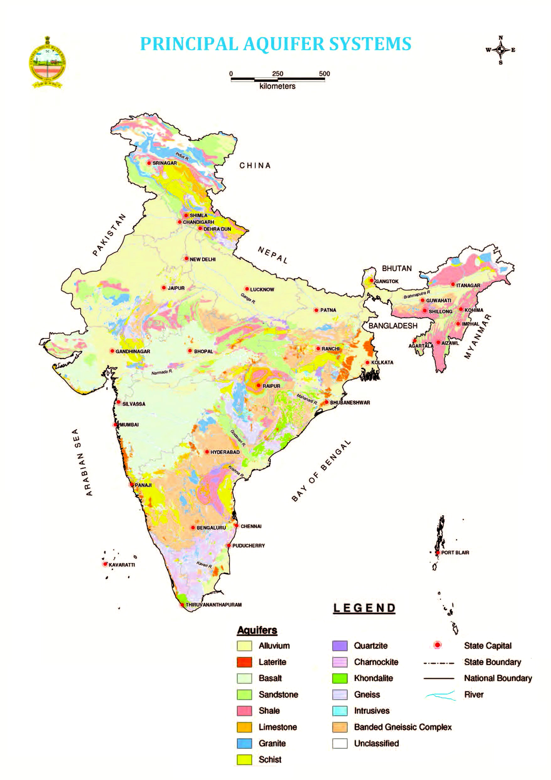

Table-4 below which provides data on ground water development as a percent of wahter recharge for indivisual states.
| State | Ground water development in 2011 (%) |
| Andhra Pradesh | 37 |
| Arunachal Pradesh | 0 |
| Assam | 14 |
| Bihar | 44 |
| Chhattisgarh | 35 |
| Delhi | 137 |
| Goa | 28 |
| Gujarat | 67 |
| Haryana | 133 |
| Himachal Pradesh | 71 |
| Jammu & Kashmir | 21 |
| Jharkhand | 32 |
| Karnataka | 64 |
| Kerala | 47 |
| Madhya Pradesh | 57 |
| Maharashtra | 53 |
| Manipur | 1 |
| Meghalaya | 0 |
| Mizoram | 3 |
| Nagaland | 6 |
| Odisha | 28 |
| Puducherry | 90 |
| Punjab | 172 |
| Rajasthan | 137 |
| Sikkim | 26 |
| Tamil Nadu | 77 |
| Telangana | 55 |
| Tripura | 7 |
| Uttar Pradesh | 74 |
| Uttarakhand | 57 |
| West Bengal | 40 |
| Total * | 62 |
| * Total includes Union territories |