

Background
Dams have been given very much importance around the world for they are believed to bring immense help in agriculture, in irrigation, in producing electricity etc. J. Nehru, at one time had called dams ‘the temples of modern India’. “At independence, in 1947, there were fewer than 300 large dams in India. By the year 2000 the number had grown to over 4000, more than half of them built between 1971 and 1989. At present there are 4877 completed large dams and 313 large dams are under construction in India.* India ranks third in the world in dam building, after US and China. While some of these dams were built mostly for flood control, water supply, and hydroelectric power generation, the primary purpose of most Indian dams remains irrigation.”1
“Most irrigation dams in India are embankment dams. That is, they consist of a wall built across a river valley to impound water so as to form a reservoir upstream and a system of spillways and gates to bypass the wall so as to maintain normal river flow and convey water to a network of canals feeding irrigated regions downstream. The upstream areas that feed the dam and those submerged by its reservoir make up its ‘catchment’ area, and the downstream areas fed by its irrigation canals make up its ‘command’ area.”2
“While these dams have helped increase India’s irrigated area and provided a semblance of food security, they have also created more problems than they have solved. What is worse, these dams have not really achieved what they had promised. While the nation and its most deprived people have paid a huge price in terms of displacement and ecological costs, the farmers for whom the water was meant have not benefited as planned.”3
Water dams and reservoirs have primarily been used to serve four functions:
- Irrigate crops
- Provide hydroelectric power
- Supply water
- Control flooding
In the global context “Out of the 38,000 large scale dams registered by the International Commission on Large Dams (ICOLD), an international organization that sets the standards for dams, 50 percent are used for irrigation, 18 percent for hydropower, 12 percent for water supply and 10 percent for flood control and the rest for other functions.”4
In the article below we will see how effective they have been in bringing benefits and serve their above mentioned purposes and how much harm they have done and in what ways they have done it. First let us look at benefits brought by them.
Benefits of Dams
- Irrigation
“The vast quantities of water in reservoirs allow them to act as effective and steady sources of water for irrigation with minimal seasonal fluctuations. 30 to 40 percent of the 271 million hectares that are irrigated worldwide rely on irrigation dams. A study done by the World Commission on Dams (WCD), a commission organized by the World Bank and the World Conservation Union (IUCN) to assess the effectiveness of large dams, showed that dams built for irrigation typically are unable to provide water for the planned area of land initially, but the performance improves over time. According to the WCD, half of the 52 large water storage projects for irrigation it examined failed to meet the expected goals the dams had been initially planned for. However, the general trend shows irrigated area increasing from 70 percent in five years to 100 percent of the planned area in ten years. The dams examined by the WCD that did not meet their initial goals often had failures at the management or organizational level rather than structural or engineering deficits.”5
For India, according to WCD, the figure of total area irrigated by dams stands at 30%-35%. Below is the figure from the report providing “data of various countries on percentage of irrigated area with water sourced from dams.”6
Figure 1. Agricultural land irrigated from dams

But here it must be pointed out that there is a great potential of increment in this respect. There has been underutilization in this regard. Various factors contribute to this, like corruption in implementation etc. “Perhaps the most telling statement in this regard has recently come from the chief minister of Maharashtra, the state with the highest number of dams in India. Intervening in a debate in the state assembly on July 21, 2017, Devendra Fadnavis remarked that Maharashtra has 40 per cent of the country’s large dams, “but 82 per cent area of the state is rain-fed. Till the time you don’t give water to a farmer’s fields, you can’t save him from suicide. We have moved away from our vision of watershed and conservation. We did not think about hydrology, geology and topography of a region before pushing large dams everywhere. We pushed large dams, not irrigation. But this has to change.””7
“Between 1951 and 2000, India’s production of food grains increased fourfold, from 51 million tons to about 200 million tons. This not only obviated the importation of food grains, with attendant saving in foreign exchange, but left India with a marginal food grain surplus. Proponents point to the fact that about two thirds of this increase was in irrigated areas. The most optimistic estimates attribute 25 percent of the increase in food grain production to dam irrigated areas. But it is incorrect to attribute the entire production gains in dam irrigated areas to dams. First, the increase in irrigation coincided with increased uptake of other inputs and technologies, such as high yield varieties beginning in the 1960s, fertilizer, machinery, and multi-cropping. Even though the contribution of these cannot be readily disentangled, we can surmise that it lowers the proportion of the productivity increase due to irrigation alone.”8
- Hydroelectric Power
“Dams can harvest gravitational potential energy to provide electrical power at low rates. Nineteen percent of world’s electricity supply comes from hydroelectric dams. Hydropower dams are able to reach their targets within five years, and around fifty percent of the hydropower dams worldwide actually exceed their targets.”9
India is the 7th largest producer of hydroelectric power in the world. As of 30 April 2017, India’s installed utility-scale hydroelectric capacity was 44,594 MW, or 13.5% of its total utility power generation capacity. There are various other multipurpose dams under construction in India which are expected to increase the generation of hydro power for the country. For example, the third phase of the Tehri Hydro Power Complex: ‘Tehri Pumped Storage Plant (PSP)’ is expected to add another 1000 MW to the sum. Recently unveiled Sardar Sarovar Dam has added another 1450 MW.
- Supply of Water
“The water in the reservoirs can be sent to treatment plants to make it suitable for drinking. The reservoir already provides some filtration since silts and other particles settle to the base of the reservoir and algae and aerobic bacteria destroy harmful microorganisms. Water supply dams are not very good at reaching their intended levels of operation even after a decade of operation: 70 percent of the WCD’s 52 sample dams did not reach their targets even after long periods of time while around 25 percent of water supply dams have reached less than half their supply goals.”10
In India supplying drinking water is one of the major reasons that gives boost to the proponents of dams here. “For example, the Tehri dam is expected to provide 270 million gallons of drinking water per day to Uttaranchal, Uttar Pradesh and Delhi. In other words 300 Cusecs (162 million gallons per day) of drinking for Delhi which will meet the requirements of about 40 lac people. In addition, 200 Cusecs (108 million gallons per day) of drinking water for towns and villages of U.P. which will meet the requirement of 30 Lac people.”11
- Flood Control
“Reservoirs can act to prevent floods downstream by holding and regulating the flow during major flood events. Reservoirs can also be used to balance flow during different weather conditions, such as decreasing the flow by holding water back during heavy rainfall and releasing more water during droughts.
- Multipurpose Dams
Some dams combine two or more of the uses stated above, but a majority of large dams, as registered by ICOLD, (International Commission on Large Dams) are single purpose. Multi-purpose dams are complex and tend not to perform as well as single-function dams. Also, for certain combination of functions, a delicate balance has to be maintained. For example, irrigation, hydroelectric and water supply dams require the reservoir to be at full capacity for efficient functioning while flood control requires water levels to be lower than maximum to hold the extra surging waters.”12
Financial Costs Involved in Dam Projects
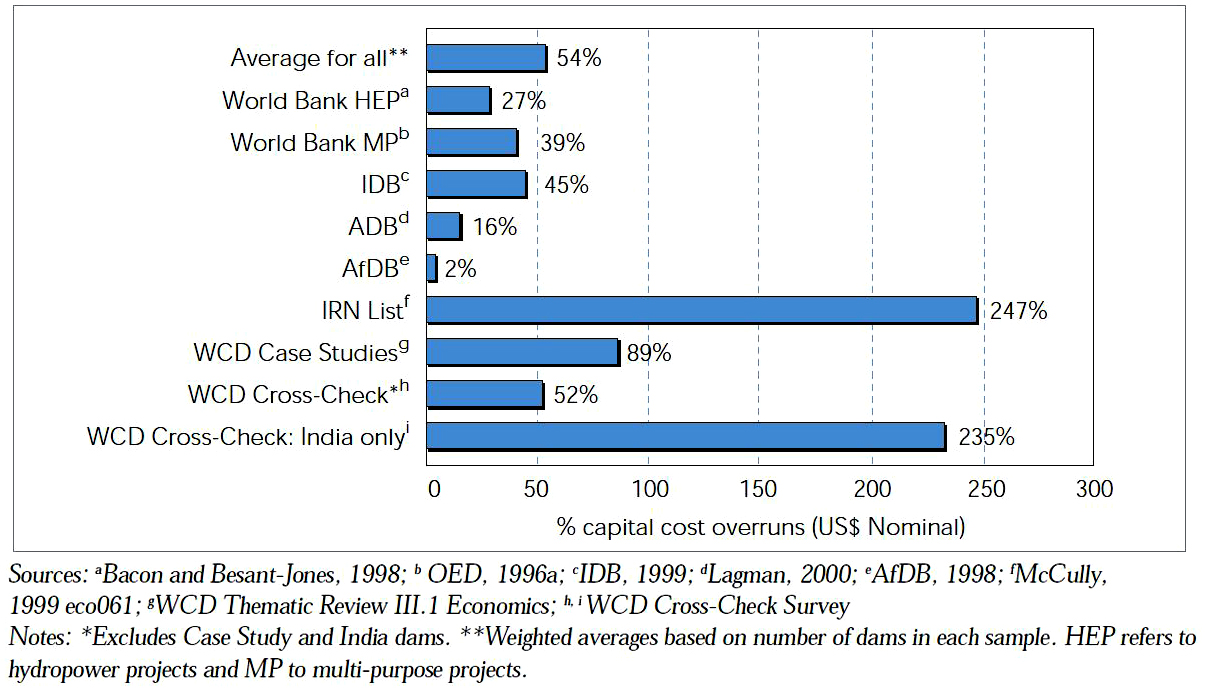
These are the major benefits of the dams that are cited by the proponents of dams building. But here we must note that a theory and its implementation are two very different things. Unfortunately, particularly in India, the implementation aspect has been plagued by slow bureaucracy and rampant corruption in all the fields, which is not surprising given the corrupt and grossly utilitarian spirit of the government machinery in India. Slow implementation, cost overruns are the major problems. According to the WCD report “…the WCD reviewed the portfolio of large dam construction projects financed by the Asian Development Bank (ADB) between 1968 and 1999. Of the 23 completed ADB large dam projects with available data, there was an average cost overrun of 16%. This masks considerable variability, as the majority of large dams in the ADB sample actually had cost underruns. The International Rivers Network (IRN) submitted a list of 14 large dams with cost performance data that showed a 242% overrun, with eight projects in India dominating the results with an average overrun of 262%. The results from these latter dams, as well as the results for the Indian dams in the Cross-Check (235% overrun) confirms the serious overruns reported in the India Case Study.”13
Below is the data figure from WCD report on Average cost overruns for large dams.
Figure 2. Average cost overruns for large dams
To take a particular example in the case of Tehri dam: “The Central Bureau of Investigation is currently investigating six cases of corruption against high-ranking officials of THDC (The company that is building and managing Tehri dam) for embezzlement of public money. The Hanumantha Rao Committee report expressed concern about the high incidence of corruption in the rehabilitation process.
The projected cost of Tehri Dam had gone up from $612 million in 1994 to $1.2 billion in 1999. A Cost benefit analysis commissioned by the Indian National Trust for Art and Cultural Heritage (INTACH) concluded that the construction costs for Tehri are twice the projected benefits.”
“A cost-benefit analysis suggests that the dams are, on average, only marginally cost-effective, although there is large variation from dam to dam. We also estimate that large dams increased all-India agricultural productivity by about 9 percent, a number close to the World Commission on Dams’s estimate of 10 percent, which has been criticized as too low by proponents of dams.”14
Having seen the major benefits of dams, we now move to the negative impacts and cons of dams.
Adverse Impacts of Dams
Environmental Effects
a. Waterlogging and Salinization:
“In most simple terms, waterlogging – accumulation of excess water in the soil – occurs when there is an imbalance in the inflow and outflow of water in an area. Every part of land has, over centuries, developed a natural equilibrium between the water inflow – in the form of rain, underground flows etc. – and the outflow, in form of surface and subsurface flows and drainage, evaporation and so on. Massive “non-natural” inflow of external water from canal irrigation without equivalent outflow disturbs this equilibrium and results in rising water tables as the excess water percolates into the ground and accumulates. The accumulating water can come from direct seepage from the canals or from field applications of irrigation.
Another form of waterlogging is the temporary surface ponding of monsoon or flood waters. This can be due to several reasons, including disruption of natural drainage due to construction of canals, roads, blockage of drains etc. Another reason is that when waterlogging – in terms of rising water tables has already taken place, then the capacity of the ground to absorb monsoon waters diminishes and this too can lead to surface ponding.
As water accumulates, the level of ground water rises. When this reaches the crop root zone, it starts to have a serious impact on crop productivity, ultimately making the land totally unproductive and rendering the land into a wet desert.
This water dissolves the salts from the soil, and brings them to the surface, where they are deposited as the water evaporates. This results in the salinization of the soil, again, affecting productivity adversely. Both these phenomena normally go together. Another important mechanism of salt deposition is the irrigation water itself – whether from the canals or from groundwater. When the irrigation water evaporates, the salts that it contains are left behind. It is estimated that the canal waters bring two million tonnes of salt on the soil in Haryana every year [canal water from Bhakra dam].”15
This problem is very serious for the large dams in India. Bhakra Nangal Dam, Tawa dam in MP are very revealing examples of this problem. A report on Bhakra Nangal Dam states, “Waterlogging not only affects the agricultural land and crop productivity but also affects the growth of trees and other plants….
Waterlogging obstructs or stops the normal circulation of air in the soil root zone inhibiting activity of soil bacteria as oxygen is not drawn in the soil and carbon dioxide liberated by the plant roots cannot be dissolved and carried away. The concentration of carbon dioxide reduces the decomposition of organic matter…lacking nitrogen fixation and thereof nitrogen deficiency. The high water table and waterlogging do not permit room for growth of plant roots… In waterlogged area the agricultural operations are either impossible or difficult. The crop yield is also very poor or negligible.
According to Bhamrah, in the areas which have become waterlogged and salt saturated, the crop yields have substantially decreased. He mentions a study which finds yields of paddy and wheat were 41% to 56% lower and net incomes in salt affected lands were 82% to 97% lower than unaffected lands. More generally:
The adverse effects of water logging and soil salinity/alkalinity render fertile soil unproductive and sometimes even barren. … According to the Ministry of Water Resources (1991), an area of 5.8 million hectare was suffering from both these problems in the commands of major/medium irrigation projects in our country. This hinders the use of irrigation resources costing about 24,000 crore rupees… an annual loss of Rs. 2800 crores. The loss of food grains were calculated as 17 m tonnes which cost about Rs. 7000 crores.
Waterlogging does not affect only agriculture. It also has a devastating impact on trees, on roads, buildings and infrastructure. It also leads to much higher flooding as the ground, already saturated with water, does not allow the rainfall to permeate and all of it is converted to run-off.
The phenomenon, according to Ghassemi et al. is “threatening the livelihood of one million farmers and their families, and having a significant influence on the food grain production of Haryana and in turn of India as a whole.”
Vast areas are affected by waterlogging and salinity in Punjab and Haryana including in the command area of the Bhakra project. Some tend to dismiss the twin problems of waterlogging and soil salinization as a temporary phenomenon, a by-product that can be “dealt with”, or something that affects a small part of the canal commands.
According to B.G. Verghese: “The thesis that Bhakra and the green revolution it sustains has devastated the land with waterlogging, salinity and chemical toxicity leading to soil death is patently absurd. There are certain problems of land and water management but these are being addressed. Alarms about salinity and waterlogging have been sounded in India since the development of the Ganga canals 140 years ago. Not that this should breed complacency; but there is little cause for despair.”
But the figures, and official documents, tell an entirely different story.
As per Shri Vinay Kumar, Vice Chancellor, CCS Agricultural University, Hissar: “In Central and south-western regions of Haryana …. canal irrigation has led to the problems of water-table rise, waterlogging, flooding, and secondary soil salinization…. A current estimate of saline and waterlogged areas in the state is around 4000 sq. km [400,000 ha] and if suitable measures are not taken, the areas with such problems are likely to increase to about 20,000 sq. km within the next 2-3 decades.”
As the irrigated area of Haryana is about 28 lakh hectare, this means that already about 14% area is affected and this can go up to 70%. Unfortunately, available data is often not categorized as per project commands; it is often only at the state level, or categorized as per districts. Tanwar (1996) quotes the following data about Punjab and Haryana (for the whole states) for 1990-91 from Statistical Abstracts:”16
Haryana 249,000 197,000
Punjab 200,000 490,000
It would not be wrong to say that this would have increased much more by now. According to a recent report published in tribuneindia.com: “The twin problem of soil salinity and waterlogging is reaching an alarming proportion in Haryana, as around 10 per cent of the state’s land has a water-table less than 3-meter deep. As per Central Soil Salinity Research Institute (CSSRI), an organisation working under the Indian Council of Agriculture Research (ICAR), nine districts are hit by the problem. The extent of salinity in a waterlogged area is 35 to 40 deci Siemens per meter (dS/m) against the normal limit of 2 dS/m. To put this into perspective, consider the salinity of sea water: 25 dS/m. An additional 3.8 lakh hectares has a water table between 1.5 meter and 3 meter, rendering it potentially waterlogged and saline land. “Most of the existing and potential waterlogged saline soils occur in arid and semi-arid regions in central inland depression basin of the state, encompassing Rohtak, Jhajjar, Bhiwani, Hisar, Sonepat districts and some parts of Jind, Fatehabad, Sirsa and Palwal districts,” said Sushil Kamra, a principal scientist at the CSSRI in Karnal.”17
If we take case study on Bhakra, the problem comes into greater focus. To quote from the report, “We visited several places in Haryana and Punjab affected by waterlogging and salinity and witnessed the great havoc that these have played with the lives of people. Some of these are outlined below.
Village Badopal, District Fatehabad, Haryana
Badopal lies on the NH 10 between Hissar and Fatehabad. Badopal was initially a part of the Yamuna command. Around 1955, the village came under the Bhakra command. Until 1985, the canals were completely unlined. Since the canal here is the Fatehbad branch, it is always flowing.
The waterlogging problem in this village first became evident in 1978. The problem assumed very serious proportions. According to the local patwari, the problem was so severe that the water would stand in the field. From 1986 to 1989, it was not possible to take any crop whatsoever. Even after the lining, the problem still remains. It is not possible to take a proper crop in kharif season, and cotton was impossible to grow. The only crop here is the rabi wheat. The people in the village confirmed that since 1978, they had not been able to take the shravani (kharif) crop at all. Some people could not even take rabi crop. About 75% of the lands have been affected by waterlogging. As a result of this, for about 25% of the people the financial position had become very bad and they were in debt.
Apart from the crop production, there have been other very severe impacts due to waterlogging. The people told us that the houses had sunk into the ground up to 2 feet. The temple that was built just in 1992 has sunk in (baith gaya hai). The trees have also died due to waterlogging (ped bhi jal gaye sem se). The buildings are also being damaged – they have to be repaired every year. In all the buildings in the village, there is seepage from the sides. At one time the situation was so bad, that the cattle used to get stuck in the ground. If four people sat on a khat (cot) it would sink into the ground. They could not even go for toilet outside – there was no place that was not waterloggged for several kilometres.
We visited a factory building in this village. The whole building is sinking, with differential settlement of the sides. So the owners have put in various types of supports and reinforcements – rods, lintels etc. New buildings are also developing cracks in the village within 2 years. We were also told that the national highway NH 10 had to be lifted some 6-7 feet due to problems of waterlogging – this was in a patch of 3-4 kms.
We also visited the water works of the village which was on the main road. This was supplying water to Badopal and Dharni villages. This was abandoned last year because the waterlogging had come up and destroyed the water tanks. The ground water had seeped into the water tanks. Ground water is saline here. The village johad (tank) was good before, but is now destroyed because of waterlogging. Now even the cattle do not drink from the johad. Even the wells are similarly affected.”18
There are many more examples of this, each more depressing than the other. And the situation is not particular to Bhakra command area only. Tehri command area and many others suffer from the same fate. In conclusion the dams were made for helping irrigation but ended up destroying agriculture and the land itself. It is natural that this problem would occur under such setup but the problem is aggravated by the lack of proper management of canals and drainage etc. As a consequence, it ends up destroying land, agriculture, groundwater, homes etc.
b. Changing Aquatic Ecosystems
“Habitat loss is the biggest cause of extinction. Freshwater habitats are thought to be the habitats that face the highest loss of biodiversity. Building a dam in a river causes great changes within the river and leads to great changes in the river systems, leading to habitat loss. The structure of the dam itself acts as a barrier preventing fish populations from migrating along the river. The formation of a large still body of water in place of a small rapidly moving body of water changes the dynamics of the water system, which makes it less suitable for the original species to survive, which may lead to extinction. The temperature and chemical composition of water in the reservoir is also different from that of the flowing river. The reduced water flowing downstream causes the water downstream to be more saline, making it less suitable for certain fish nurseries and also enables predators to reach them. The water running off from the catchment areas upstream carry with them sediments and nutrients. This may lead to eutrophication, (excessive richness of nutrients in a lake or other body of water, frequently due to run-off from the land, which causes a dense growth of plant life) which eventually leads to the loss of most species in the reservoir.
For example, river dolphins of the Yangtze (China) became extinct after the Three Gorges Dam was built; the variety of fishes, dolphins in the Mekong region are also at risk of extinction. The Glines Canyon Dams in the Elwha River in Washington, USA, has been responsible for almost wiping out the entire steelhead trout and salmon population.”19
“Many species of peninsular and Himalayans rivers in India migrate short or long distances for spawning. Any obstruction in the spawning routes affects recruitment (In biology, especially marine biology, recruitment occurs when juvenile organisms survive to be added to a population, by birth or immigration). Dams, without provisions for fish migration have a major impact on fisheries. This is an established global phenomenon and a number of countries are trying to mitigate this problem. United States has decommissioned more than 1000 dams in the past decade and many of these were decommissioned to reinstate migratory runs of fish like salmons and steelheads. There is a lot we can learn from the US experience. According to World Commission on Dams Report 2000, “Substantial losses to downstream fishery production have occurred as a result of dam construction around the world.” Hilsa fisheries in Cauvery collapsed in the upstream after the Mettur Dam. Puntius species also disappeared in Cauvery, which formed 28% of the landings prior to dam construction. Mahseer, once an abundant game and food fish in India is now on the list of endangered species, with extremely limited range in rivers like Narmada, where it was abundantly found. Mahseer has been virtually wiped out from all Indian rivers due to dams and barrages and upcoming dams in North East and Himalayas will compound this problem. Tehri Dam on Bhagirathi has already impacted Mahseer migration to a great extent.”20
c. Sedimentation
“The decrease in water flow due to the reservoir leads to water losing the sediments it carries, to the bottom of the reservoir. This decreases the water storing potential of the reservoir and also decreases the silt and nutrients from being carried downstream, makes soil downstream less fertile, which harms the plants and animals that live and grow there, since the reduced fertility will reduce the number of plants and trees that can grow downstream and so, cause the number of animal habitat to drop, decreasing the biodiversity of the area. Because of the drop in the number of trees that can grow and hold soil together, the soil is more prone to erosion, meaning the structure of the soil is lost, making it less and less suitable for human or animal habitation.”21
d. Greenhouse Gas Emission
“The condition at the base of the reservoir is anaerobic, meaning that vegetation under the reservoir are decomposed by anaerobic bacteria that give out greenhouse gases such as methane and carbon dioxide. According to the WDC, if the area being flooded during the reservoir filling is not cleared out, the amount of greenhouse gases produced could be higher than for the same amount of energy produced by a coal powered station. However, power generation from the dams does not cause emission of gases such as sulfur dioxide, nitric oxide and carbon monoxide which are responsible for acid rain and blood poisoning, making them more eco-friendly in this sense than fossil fuels such as coal, which does produce these gases when burned.”22
e. Submergence of Forests:
For India “Data was available on forest submergence for 60 dams. On the basis of these, the average forest area submerged per dam works out to approximately 4,879 ha. Therefore, the 1,877 dams built between 1980 and 2000 would have submerged 9,157,883 ha. (roughly 9.1 million ha.) of forests. The CWC has stated that, according to a study of 116 projects (details not available), the average forest submergence per project was 2,400 ha. Even if we take this to be the correct figure, the total submergence between 1980 and 2000 would have been 4,504,800 ha. (roughly four and a half million hectares).
The most common mitigative measure prescribed is compensatory afforestation. However, available evidence indicates that “compensatory” afforestation is difficult to implement, and in some cases was not complete many years after completion of the project. According to the Ministry of Environment and Forests, the performance of state governments in compensatory afforestation has not been very satisfactory. Till 1997, only 46% of the area stipulated to be afforested had even been taken up.
Also, it is impossible to replace a natural forest by a plantation. Therefore, even if there is formal ‘compensation’ for the forests lost in terms of forest area, the actual ecological and biodiversity losses that the destruction of natural forests imply cannot be compensated.
f. Wildlife Losses:
“Apart from forests, the reservoir and the dam also affect other ecosystems and various fauna and flora species. Unfortunately, till recently, there was little effort to assess the impact on flora and fauna and on non-forest ecosystems. Even where studies were conducted, there was a tendency to consider only large mammals as ‘wildlife’.
Recommended mitigation included the creation of bridges for the movement of elephants (Dalma-Subernarekha Project) and the creation of sanctuaries (Sardar Sarovar). In some cases, it was suggested that there would be no impact on wildlife as they would migrate to neighbouring forests. For example, a study done on the impact of the Indira (Narmada) Sagar project on wildlife, by EPCO (Environmental Planning and Coordination Organisation) in Madhya Pradesh, suggested that the wildlife would either voluntarily migrate into neighbouring forests when impoundment took place or could be driven there by squads of specially trained staff. Similarly, studies done in relation to the Tehri project maintained that the fish would migrate and establish themselves upstream of the dam. For the Rajghat project, it was suggested: “The national park at Shivpuri is not far off. It is thus felt that there is ample scope for migration of wildlife to the adjoining forests and there would be no difficulty on this account.” The CWC also states that “wildlife could be shifted and rehabilitated. Birds will migrate on their own.”
But do the animals and birds know this? And the areas where these animals would hopefully move into are not ‘vacant habitats’ available for occupation by displaced animals. They have their own complement of wildlife. Besides, wild animals are rightly wary of leaving their own territory and panic when waters flood in. Some animals are nocturnal, others roam around during the day; they live underground or on trees and in caves. And what about plants and insects and reptiles and micro-organisms, which also constitute wildlife?
i. Impacts of Power Lines:
Very often corridors have to be cut through forests and other natural ecosystems to accommodate power lines. This adversely affects the terrestrial ecosystems. These corridors also have to be maintained in order to allow repair and upgradation work on power lines, causing a long-term impact. In the Uri project, for example, 98.54 ha. of forestland was given clearance for transmission lines in Jammu and Kashmir. In the ongoing Tehri project, power lines are not only resulting in the felling of a large number of trees in the Himalayas but are also passing through the Rajaji National Park. Power lines, especially high-tension lines, are also known to produce high levels of radiation, affecting ecosystems and human beings. High-tension power lines can also cause fires and be hazardous to birds and animals.”23
j. Evaporation
“Reservoirs have large open surfaces that facilitate water loss by evaporation, and much more water is lost in the same period of time from reservoirs than was originally lost from the river that flowed in its place. Even though the loss mainly depends on the climate of the area, it can also depend on the size, shape and depth of the reservoir, with reservoirs having smaller surfaces or larger depths losing less water. This added evaporation can affect the microclimate of the area as it reduces fluctuations in the extremes temperature and may change the ecosystems that can exist there, since organisms suited to the two extremes of temperatures, or which need the fluctuation as part of their breeding cycles cannot survive.
k. Seismic Activity
It has been known that the filling of reservoirs of large dams has triggered seismic activity because of the physical change incurred in the area where the reservoir was filled, and the activity of the dam. Scientists have traced the cause of over 100 earthquakes worldwide to dams. In May 2008, the 7.9-magnitude earthquake in Sichuan (Sichuan is a southwestern Chinese province) that killed 80,000 people has been linked to the construction of the Zipingpu Dam, and is possibly the most serious earthquake caused by a dam.
(Reservoir-Induced Seismicity) “RIS has occurred in various dams across the world. 17 of the 75 cases of RIS reported worldwide have been reported from India.””24
Over 670 large dams across the country fall within high-intensity seismic zones. The dams are located in either seismic zone IV or V. The seismic zoning map of India, prepared by the Bureau of Indian standards, divides the country into four seismic zones from Zone II to the most vulnerable Zone V. The highest number of dams in high-intensity seismic zones are in Gujarat with 444 large dams, followed by Maharashtra with 170 large dams.
The Tehri dam, largest in India is most prone to seismic problem. “The design of the dam was finalized in the 1960s when scientific understanding of seismic hazards and seismic engineering solutions were far less advanced than today. Tehri Dam is situated in the highly active Central Himalayan Seismic Zone. It is designed to withstand earthquakes of up to 7.2 on the Richter scale although experts predict that earthquakes of magnitude 8.5 or more could strike this region. If the dam were to burst, several major towns downstream of the dam with a total population of over half a million people could be wiped out. Landslides are common on the steep slopes above Tehri’s reservoir. A major landslide into the reservoir could cause a huge wave, which could overtop the dam and cause massive damage downstream. It would bury the towns of Rishikesh, Hardwar, Bijnor, Meerut, Hapur and Bulandshahar within hours and devastating large areas of the Gangetic Plains.”25
l. Impacts of Water Flow Variation Downstream
“The variation and reduction in water flow in the river adversely affects water availability downstream, both from surface sources and because of inadequate recharging of groundwater. Diversion of water into canals also results in less water downstream, affecting ground and surface water resources. There are also huge water losses from the canals and the reservoir. According to official sources, in Malaprabha, (Karnataka) for example, “Conveyance losses in both lined and unlined systems are generally 300% of those assumed. In MLBC, (Malaprabha Left Bank Canal) in lined reaches, losses are as high as 7.48 and 20.24 cumecs/M. sq. m. against an assumed loss of 0.61 cumec/ M. sq. m.” Similarly, in the Hasdeo Bango (Chhattisgarh) project, “Seepage losses in the conveyance system are two to three times more than the designed conveyance losses.”
- Pollution: Reduction and variation in the flow of the river also results in the increased concentration of pollutants downstream, during dry seasons.
- Saltwater ingress: Where the quantity and force of water reaching the river mouth and flowing to the sea is reduced, there is a danger of saltwater ingress. Such ingress can not only destroy riverine and terrestrial ecosystems but can also contaminate groundwater resources.”26
According to an article published in TOI (Times of India), “The Cauvery in Tamil Nadu, which is the lifeline of agriculture on some 88,000 sq. km across Karnataka, Andhra Pradesh, Tamil Nadu and Puducherry, is dry hundreds of kilometers before it meets the Bay of Bengal. And the sea, as if in search of the river, is making incursions inland – with disastrous results.
Seawater incursion up to 20km upstream in parts of the Cauvery delta which includes Thanjavur, the rice bowl of TN is ruining soil fertility in Tiruvarur and Nagapattinam districts of the state. S Janakarajan of Madras Institute of Development Studies says groundwater in Nagapattinam, at the tail-end of the Cauvery, is 100% saline and up to 60% in Tiruvarur.
“The incursion has been rapid in the past few years. It has also affected the soil in Nagapattinam. If water doesn’t flow in partnership with our rivers, our food security will be threatened,” he says.
This salinity has rendered 2.32 lakh hectares of farmland in Cuddalore, Nagapattinam and Thanjavur districts unsuitable for cultivation, says S Dhanapalan, president of the Cauvery Delta Farmers’ Association. “About 57% of this is completely affected by salinity and cultivation in the rest is dependent on rain,” he added.
Besides, seawater incursion into Kollidam river, a branch of Cauvery, has also contaminated groundwater. As many as 150 villages, including Chidambaram and Bhuvanagiri, along the coastal belt are struggling for drinking water, says P Vinayagamoorthi, president of Kollidam, Keelanai Farmers’ Association. The situation improves a bit occasionally, when Kollidam is in spate, he added. Former chief minister J. Jayalalithaa had in August 2014 announced construction of a barrage across Kollidam to stop seawater incursion. Unless the project is implemented, people will continue to suffer, Vinayagamoorthi said adding that the government should also put an end to excessive extraction of groundwater wherever it is possible.”27
m. Impacts of Sudden Release of Water or of Dam Failure
“Degraded catchments, excessive rainfall or over-filling of reservoirs, may make it necessary to suddenly release large quantities of water from the reservoir in order to protect the dam structure. Such sudden releases can be disastrous for people living downstream, for their crops and for entire ecosystems. Reportedly, such releases occurred twice from the famous Bhakra dam, in the late 1970s and again in 1988. Another case was that of the Rihand dam. In 1997, huge amounts of water were suddenly released and flooded 175 villages in Rewa district of Madhya Pradesh as well as Rewa town, killing 14 people and causing an estimated damage of Rs. 200 crores.
The failure of the dam, where the structure collapses and allows the reservoir to partially or totally drain out, is a catastrophe for downstream ecosystems and human populations. There are many causes of dam failure. It can be due to faulty design or construction, use of sub-standard materials, over-topping due to surplus water, deliberate sabotage or bombing [by terrorists]or because of severe earthquakes. In some cases, where the dam structure might remain intact, the neighbouring hillsides crumble having the same effect as the dam collapsing.
According to the World Bank, in the case of the Manchu dam-II (Morbi District, Gujrat), “The initial design flood capacity of the spillway was 200,000 cusecs based on an estimated PMF (probable maximum flood) of 191,000 cusecs. However, in August 1979, the dam was over-topped by a flood of 460,000 cusecs. Within 20 minutes floods of 12-30 ft. height inundated the low-lying areas of Morbi town, resulting in deaths of around 5000-10000 people. Following this, a complete review of the hydrology was conducted, which led to a revised PMF estimated at around 739,000 cusecs, which was nearly four times the original design flood. Even as this revised design was about to be built, an even greater flood occurred which required the PMF to be raised still further to around 933,000 cusecs. This is a five-fold increase on the original design flood in just 20 years.”28
Social Effects
a. Displacement of People
“An area to be flooded for use as a reservoir has to be cleared of human population. It is estimated that 40 to 80 million people have been displaced by dam construction worldwide. To mitigate relocation damage, such as loss of home and livelihood, governments need to protect both the populations that are being displaced and the ones that accept them. These efforts must be made in conjunction with affected peoples who live downstream. Affected peoples should be compensated. Compensation, however, often is rarely or poorly implemented. For example, in China, populations who were forced to resettle for dam construction became much poorer than they had been previously and worse off than those around them who did not move. Around 70 percent of all re-settlers were living in ‘extreme poverty’.”29
According to the report by WCD, “In India the estimates of people displaced due to large dams vary, from 21 million to 33 million people. Dams account for 34% of all people displaced by development projects in China (displacement due to city construction included in the total), 77% in India (urban displacement not included to total displaced). All these figures are at best only careful estimations and certainly do not include the millions who may have been displaced due to several others aspects of the projects such as canals, powerhouses, project infrastructure and associated compensatory measures such as bio-reserves etc.”30
b. Human Health Risks
“For reservoirs in the tropical regions of the world, especially those that are below 1,000 m. elevation, there is a significant threat of vector breeding. Mosquitoes, which are carriers of malaria, filaria, dengue and other diseases breed in small pools of water created on the edges of the reservoir due to the lowering and raising of the water level of the reservoir. In some areas, snails, which are carriers of schistosomiasis (Schistosomiasis, also known as snail fever and bilharzia, is a disease caused by parasitic flatworms called schistosomes.), are also found to proliferate because of dams. The correlation between the spread of vector-borne diseases such as malaria and irrigation projects has been well studied and established. In various projects, for example Sriram sagar (in Telangana) and Ukai, (in Gujarat) the incidence of malaria reportedly increased after impoundment. Raichur district in Karnataka became highly endemic for malaria after the construction of the Tungabhadra dam and its canal network. In the Sirhind feeder canal command area, (Punjab) there was a “menacing increase in mosquitoes”. Further, fluorosis was also noticed in Nagarjunasagar (Telangana). Genu valgum, a crippling bone disease associated with skeletal fluorosis, developed in young people, especially males.
The setting up of primary health centres and the spraying of pesticides are the two most common responses to the threat to human health. Unfortunately, the first is a curative rather than a preventive measure. Also, the effectiveness of pesticides is doubtful. Besides, the application of chemical pesticides results in other health hazards, which also need to be assessed and tackled.
New agricultural practices, many of which are a consequence of the irrigation waters brought in by dams, also promote the use of chemical pesticides and fertilizers. These have well recorded and significant adverse impacts on the environment and on human health. However, though the benefits of the anticipated increases in agricultural productivity are taken as a benefit of dams, the resultant costs of pesticides and fertilizers on the environment are very rarely computed or even studied.”31
Conclusion
Some of the conclusions WCD has included in their final report are:
- Dams have made an important and significant contribution to human development, and the benefits derived from them have been considerable. Nothing further than this statement is reflected in the Report.
- In too many cases an unacceptable price has been paid to secure those benefits, especially in social and environmental terms, by people displaced, by communities d/s, by taxpayers and by the natural environment. (social, environmental, equity).
- Irrigation and flood control dams have not performed well and therefore other options must be explored.
- Hydropower dams may continue to be built; however, it is elsewhere brought out that Green House Gases (GHG) emissions of Hydro Projects are much the same as thermal ones and should be the last resort of options.
- Large storages may be required for water supply to mega cities.
One cannot but agree to the conclusions above that dams have not been as effective as perceived, but rather in some cases even worsened situations if one looks impartially at the available figures. Especially in the Indian context so called ‘development by dams’ has come at an enormous social and environmental cost. The problem has been further aggravated by the lack of proper management and honesty in this field. To meet the ever increasing needs and greeds of the rising population of the country we have left no stone unturned and dams and these things are natural byproduct of that. If one could impartially see the environmental effects alone one would think thrice before building dams anymore and look for alternate means. But we are now building dams faster than anyone in the world along with China. Our river aquatic system is being destroyed, fishery is being destroyed, land is being destroyed, wildlife is being destroyed. We are weakening the already weak Himalayan ecosystem by this practice. Rivers are drying up. Farmers that were supposed to be helped by this are unfortunately not being helped but in some cases are even worse off. But we are blind to the consequences of our so called addiction for Western development. The Government of India has taken up the massive project of interlinking rivers of the country which would require it to build thousands of dams all over the country. There is talk of doing it the right way keeping in mind the environment, sustainability and other aspects. But this is not at all possible. They are completely opposite things. If we continue in this way, the future will be much more bleak than it is now. Some of the world’s countries are beginning to understand the extant of the problem. “A number of countries are trying to mitigate this problem. United States has decommissioned more than 1000 dams in the past decade…”32
“The engineering of dam removal is still young and untried, and the cost of dam-removal is still ignored when construction costs are estimated. How exactly to dismantle a very large dam, what to do with the sediment clogging the reservoir behind it, and how much such an operation would cost, is largely unknown. Removing a hydro dam could even cost more than building one, especially where reservoir sediments contain heavy metals and other toxic contaminants.
But momentum is building to remove more dams, and to find the best ways to take them down and restore the rivers they impounded. Dam removal campaigns are now underway in many parts of the world, some of which target very large dams. Currently, the United States – with some 74,000 dams (most of which are relatively small) – has perhaps the most active dam-removal movement. Grassroots groups around the country have launched campaigns to dismantle dams in their communities, and hundreds of small and medium-sized dams have already come down. Another sign of progress is that the American Society of Civil Engineers just published technical guidelines for dam removal – the first important sign that the dam-building industry is beginning to take this issue seriously.”33
“When the negative environmental effects outweigh the benefits, a dam may be considered for removal. This happened on the Elwha River in Olympic National Park in Washington when extraordinarily rich salmon habitat was being disrupted by an outdated hydroelectric plant. Before dams were built on the Elwha River, 400,000 salmon returned each year to spawn, but that number dropped to fewer than 3,000 after dams were put up.”34
“In 1992, Congress passed the Elwha River Ecosystem and Fisheries Restoration Act, authorizing dam removal to restore the altered ecosystem. After two decades of planning, the largest dam removal in U.S. history began on September 17, 2011. Six months later Elwha Dam was gone, followed by the Glines Canyon Dam in 2014. Today, the Elwha River once again flows freely from its headwaters in the Olympic Mountains to the Strait of Juan de Fuca.”35
“Since around 2000, most major dam removal projects, and the largest single project, the $350M removal of two Olympic Peninsula dams as part of the Elwha Ecosystem Restoration, have been driven by restoration of river habitat and fish passages. Inspired by the Elwha project, a French group called SOS Loire Vivante successfully lobbied for the removal of two dams in the Upper Loire Valley, and the re-engineering of a 1941 hydroelectric dam on the Allier River to restore habitat for Atlantic salmon.
In the United States roughly 900 dams were removed between 1990 and 2015, with another 50 to 60 more every year. France and Canada have also completed significant removal projects, and Japan’s first removal, of the Arase Dam on the Kuma River, began in 2012 and is scheduled to complete in 2018.”36
It can be argued that there might be regions in the country where there is absolute necessity for this. But this must not be generalized and applied everywhere. Having said that further studies are needed so that there is no doubt among people of the disaster we are creating. But with the given data and figures it is not wrong to say that we must shift our focus to alternate means and not push for dams as we are currently doing.
References:
- http://scholar.harvard.edu/files/rpande/files/large_dams_in_india.pdf
- Ibid
- http://indianexpress.com/article/opinion/columns/push-irrigation-not-dams/
- http://12.000.scripts.mit.edu/mission2017/dams-and-reservoirs/
- Ibid
- Dams and Development: A New Framework for Decision-Making (WCD Report)
- http://indianexpress.com/article/opinion/columns/push-irrigation-not-dams/
- http://scholar.harvard.edu/files/rpande/files/large_dams_in_india.pdf
- http://12.000.scripts.mit.edu/mission2017/dams-and-reservoirs/
- Ibid
- ‘A Case Study On Tehri Dam’ by Soumya Sandipa & Shruti Pandey (www.academia.edu/9758776/A_CASE_STUDY_ON_TEHRI_DAM)
- http://12.000.scripts.mit.edu/mission2017/dams-and-reservoirs/
- Dams and Development: A New Framework for Decision-Making (WCD Report)
- http://scholar.harvard.edu/files/rpande/files/large_dams_in_india.pdf
- ‘Unravelling Bhakra: Assessing The Temple of Resurgent India’ by Shripad Dharmadhikary, Swathi Sheshadri & Rehmat. Publisher: Manthan Adhyayan Kendra (www.manthan-india.org/wp-content/uploads/2015/04/Unravelling-Bhakra.pdf)
- Ibid
- http://www.tribuneindia.com/news/haryana/community/nine-districts-hit-by-soil-salinity-waterlogging/183588.html
- Unravelling Bhakra: Assessing The Temple of Resurgent India’ by Shripad Dharmadhikary, Swathi Sheshadri & Rehmat. Publisher: Manthan Adhyayan Kendra (www.manthan-india.org/wp-content/uploads/2015/04/Unravelling-Bhakra.pdf)
- http://12.000.scripts.mit.edu/mission2017/dams-and-reservoirs/
- ‘Impacts of Dams on Riverine Fisheries in India’ by Parineeta Dandekar (Http://sandrp.in/dams/Impacts_of_Dams_on_Riverine_Fisheries_in_India_Pa rineetaDandekar_Sept2012.pdf)
- http://12.000.scripts.mit.edu/mission2017/dams-and-reservoirs/
- Ibid
- https://theconstructor.org/structures/environmental-impacts-of-large-dams/236/
- http://scholar.harvard.edu/files/rpande/files/large_dams_in_india.pdf
- ‘A Case Study On Tehri Dam’ by Soumya Sandipa & Shruti Pandey (www.academia.edu/9758776/A_CASE_STUDY_ON_TEHRI_DAM)
- https://theconstructor.org/structures/environmental-impacts-of-large-dams/236/
- http://timesofindia.indiatimes.com/city/chennai/tamil-nadu-rivers-in-reverse-gear/articleshow/60433376.cms
- https://theconstructor.org/structures/environmental-impacts-of-large-dams/236/
- http://scholar.harvard.edu/files/rpande/files/large_dams_in_india.pdf
- Dams and Development: A New Framework for Decision-Making (WCD Report)
- https://theconstructor.org/structures/environmental-impacts-of-large-dams/236/
- ‘Impacts of Dams on Riverine Fisheries in India’ by Parineeta Dandekar (Http://sandrp.in/dams/Impacts_of_Dams_on_Riverine_Fisheries_in_India_Pa rineetaDandekar_Sept2012.pdf)
- https://www.internationalrivers.org/dam-decommissioning
- https://en.wikipedia.org/wiki/Dam_removal
- https://www.nps.gov/olym/learn/nature/elwha-ecosystem-restoration.htm
- https://en.wikipedia.org/wiki/Dam_removal